IMAGES TAKEN NEAR TO
Pannal Ash Road, HARROGATE, HG2 9JL
Introduction
This page details the photographs taken nearby to Pannal Ash Road, HG2 9JL by members of the Geograph project.
The Geograph project started in 2005 with the aim of publishing, organising and preserving representative images for every square kilometre of Great Britain, Ireland and the Isle of Man.

There are currently over 7.5m images from over14,400 individuals and you can help contribute to the project by visiting https://www.geograph.org.uk
Image Map
Images are licensed for reuse under creativecommons.org/licenses/by-sa/2.0
Notes
- Clicking on the map will re-center to the selected point.
- The higher the marker number, the further away the image location is from the centre of the postcode.
Image Listing (75 Images Found)
Images are licensed for reuse under creativecommons.org/licenses/by-sa/2.0
Image
Details
Distance


6
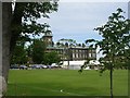
Ashville College - Yew Tree Lane
This is an independent co-educational day & boarding school.
Image: © Betty Longbottom
Taken: 24 Jun 2008
0.09 miles
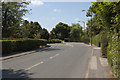
7
Green Lane - viewed from Pannal Ash Roundabout
Image: © Betty Longbottom
Taken: 3 Oct 2016
0.09 miles
8
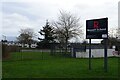
Rossett School
One of several large secondary schools in Harrogate.
Image: © DS Pugh
Taken: 31 Dec 2024
0.09 miles
9
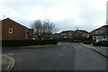
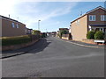
Westdene
Looking along Westdene in the Harlow Hill area.
Image: © DS Pugh
Taken: 28 Dec 2020
0.09 miles
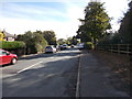
10
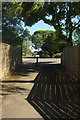
Path at Pannal Ash
Footpath 15 54/154/1 arrives at the Pannal Ash roundabout.
Image: © Derek Harper
Taken: 24 Jun 2018
0.09 miles