IMAGES TAKEN NEAR TO
Plantation Avenue, HARROGATE, HG2 0DD
Introduction
This page details the photographs taken nearby to Plantation Avenue, HG2 0DD by members of the Geograph project.
The Geograph project started in 2005 with the aim of publishing, organising and preserving representative images for every square kilometre of Great Britain, Ireland and the Isle of Man.

There are currently over 7.5m images from over14,400 individuals and you can help contribute to the project by visiting https://www.geograph.org.uk
Image Map
Images are licensed for reuse under creativecommons.org/licenses/by-sa/2.0
Notes
- Clicking on the map will re-center to the selected point.
- The higher the marker number, the further away the image location is from the centre of the postcode.
Image Listing (110 Images Found)
Images are licensed for reuse under creativecommons.org/licenses/by-sa/2.0
Image
Details
Distance
1
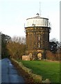
Harlow Hill Water Tower
A plaque in the wall of the tower reads, "Harrogate Corporation Waterworks 1902".
Image: © David Rogers
Taken: 9 Dec 2009
0.07 miles
2
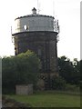
Harlow Hill Water Tower
A significant landmark at Harrogate's highest point, Harlow Hill Water Tower was built in 1902 and overlooks the Harrogate Waterworks and the town.
Image: © Roger Crowther
Taken: 23 Jun 2005
0.08 miles
3
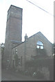
Harlow Hill Observatory
This early Victorian observatory is now a private house, but was open to the public for many years. It retained a dome until the late 20th century.
Image: © Roger Crowther
Taken: 23 Jun 2005
0.08 miles
4
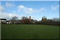
Harlow Hill Park
Looking across part of the park near the water tower.
Image: © DS Pugh
Taken: 29 Dec 2022
0.08 miles
5
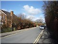
Plantation Road
Seen from its junction with Otley Road.
Image: © DS Pugh
Taken: 1 Apr 2010
0.09 miles
6
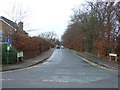
Plantation Road, Harlow Hill
Off Otley Road (B6162).
Image: © JThomas
Taken: 10 Dec 2016
0.09 miles
7
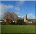
Harlow Hill Park and tower
Looking across part of the park on top of Harlow Hill.
Image: © DS Pugh
Taken: 29 Dec 2022
0.09 miles
8
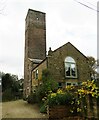
Harlow Hill Tower
An early attraction for visitors to the town in the 19th century. The tower, sometimes referred to as an observatory, was built in 1829 and is 27m high. An old guide to Harrogate of circa 1900 comments thus....'Here stands an observatory with a fine panoramic view that includes the cathedrals of York and Ripon and well-nigh two hundred parish churches.' The Victorian visitor must have been blessed with exceptional eyesight, for although York Minster is visible some 22 miles east on a clear day, the Minster at Ripon would seem to be invisible from here, even at over 600ft above the sea. On this dull November day, the view extended to the Hambleton Hills and the Yorkshire Wolds, but there was no attempt to count parish churches. The tower is now privately owned and not open to the public.
Image: © Gordon Hatton
Taken: 18 Nov 2022
0.09 miles
9
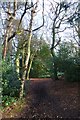
Path in the pinewoods
Looking along one of the many paths within the pinewoods.
Image: © DS Pugh
Taken: 18 Dec 2016
0.10 miles
10
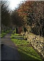
Path beside Otley Road
At the summit of Harlow Hill.
Image: © Derek Harper
Taken: 27 Dec 2011
0.10 miles