IMAGES TAKEN NEAR TO
Back Elmwood Street, HARROGATE, HG1 5HE
Introduction
This page details the photographs taken nearby to Back Elmwood Street, HG1 5HE by members of the Geograph project.
The Geograph project started in 2005 with the aim of publishing, organising and preserving representative images for every square kilometre of Great Britain, Ireland and the Isle of Man.

There are currently over 7.5m images from over14,400 individuals and you can help contribute to the project by visiting https://www.geograph.org.uk
Image Map (Loading...)


Getting Data...Please wait
Leaflet Map data © OpenStreetMap
Images are licensed for reuse under creativecommons.org/licenses/by-sa/2.0
Notes
- Clicking on the map will re-center to the selected point.
- The higher the marker number, the further away the image location is from the centre of the postcode.
Image Listing (229 Images Found)
Images are licensed for reuse under creativecommons.org/licenses/by-sa/2.0
Image
Details
Distance
1

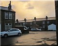
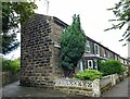
The Cottages, Back Elmwood Street, Harrogate
A pair of secluded semis seen from Elmwood Street. Behind them is a new house by the wall of Image
Image: © Derek Harper
Taken: 27 Dec 2013
0.02 miles
2
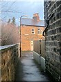
Alley, Harrogate
Seen on the left of Image], and leading from Ashfield Terrace to Ashfield Road, with Image] over the wall on the left.
Image: © Derek Harper
Taken: 27 Dec 2013
0.04 miles
3
Elmwood Street meets Ashfield Road, Harrogate
From the same spot as Image Some interesting light as the sun goes down.
Image: © Derek Harper
Taken: 27 Dec 2013
0.04 miles
4
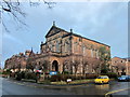
Grove Road Methodist Church
The former church, at the corner of Chatsworth Place (right) and Grove Road, date from 1896 http://list.english-heritage.org.uk/resultsingle.aspx?uid=1393406&searchtype=mapsearch . It has been sold for "community
use only".
Image: © Derek Harper
Taken: 27 Dec 2013
0.05 miles
5
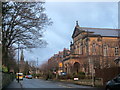
Grove Road, Harrogate
On the right is Grove Road Methodist Church: "Wesleyan, 1896. Italianate" http://list.english-heritage.org.uk/resultsingle.aspx?uid=1393406&searchtype=mapsearch . The spire belongs to the former St Luke's church - see Image The wall on the left borders Image
Image: © Derek Harper
Taken: 27 Dec 2013
0.05 miles
6
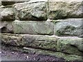
Harrogate, Ashfield Terrace
This is the south-west facing wall of 1 Ashfield Terrace. There is a benchmark on the 2nd course of stones.
Image: © Mel Towler
Taken: 8 Aug 2021
0.05 miles
7
Harrogate, Ashfield Terrace
A wider angle showing the south-west facing wall of 1 Ashfield Terrace. There is a benchmark on the 2nd course of stones.
Image: © Mel Towler
Taken: 8 Aug 2021
0.05 miles
8
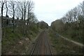
Cutting towards Skipton Road
Looking along the Harrogate Lines north of the station.
Image: © DS Pugh
Taken: 1 Apr 2021
0.06 miles
9
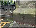
Harrogate, Grove Road Cemetery
The cemetery is on the south side of Grove Road, and this is the right hand gatepost of a pair of gates leading into the cemetery grounds. The benchmark is on the plinth base.
Image: © Mel Towler
Taken: 8 Aug 2021
0.06 miles
10
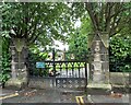
Harrogate, Grove Road Cemetery
The cemetery is on the south side of Grove Road, and cut into the plinth base on the right hand gatepost is a benchmark..
Image: © Mel Towler
Taken: 8 Aug 2021
0.06 miles