IMAGES TAKEN NEAR TO
Strawberry Dale Terrace, HARROGATE, HG1 5EQ
Introduction
This page details the photographs taken nearby to Strawberry Dale Terrace, HG1 5EQ by members of the Geograph project.
The Geograph project started in 2005 with the aim of publishing, organising and preserving representative images for every square kilometre of Great Britain, Ireland and the Isle of Man.

There are currently over 7.5m images from over14,400 individuals and you can help contribute to the project by visiting https://www.geograph.org.uk
Image Map
Images are licensed for reuse under creativecommons.org/licenses/by-sa/2.0
Notes
- Clicking on the map will re-center to the selected point.
- The higher the marker number, the further away the image location is from the centre of the postcode.
Image Listing (590 Images Found)
Images are licensed for reuse under creativecommons.org/licenses/by-sa/2.0
Image
Details
Distance
1
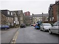
Strawberry Dale Terrace - Mayfield Grove
Image: © Betty Longbottom
Taken: 25 Jan 2010
0.01 miles
2
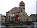
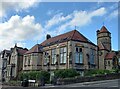
Mayfield Community Church - Mayfield Grove
Image: © Betty Longbottom
Taken: 25 Jan 2010
0.01 miles
3
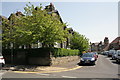
Junction of Franklin Road and Strawberry Dale Terrace
There is an OS benchmark Image on the wall of Franklin Road (the left hand road)
Image: © Roger Templeman
Taken: 24 May 2012
0.02 miles
4
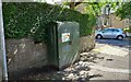
Harrogate, Franklin Road
This stretch of wall is on the east side of Franklin Road, and to the north of the junction with Strawberry Dale. There is a benchmark cut into the 1st stone course, and it is to the left of a green telecomms box.
Image: © Mel Towler
Taken: 8 Aug 2021
0.02 miles
5
Harrogate, Franklin Road
A wider angle showing a stretch of wall on the east side of Franklin Road, and to the north of the junction with Strawberry Dale. There is a benchmark cut into the 1st stone course, and it is to the left of a green telecomms box.
Image: © Mel Towler
Taken: 8 Aug 2021
0.02 miles
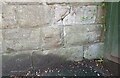
6
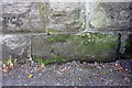
Benchmark on the wall of Franklin Road
Ordnance Survey cut mark benchmark described on the Bench Mark Database at http://www.bench-marks.org.uk/bm43167
Image: © Roger Templeman
Taken: 24 May 2012
0.02 miles

8
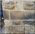
Harrogate, Mayfield Grove, converted church
The benchmark is cut into an east facing wall of the converted church. The mark is not easy to find and is more accessible from the road Strawberry Dale.
Image: © Mel Towler
Taken: 31 Jul 2022
0.03 miles
9
Harrogate, Mayfield Grove, converted church
There is a benchmark cut into an east facing wall of the converted church. The mark is not easy to find and is more accessible from the road, Strawberry Dale.
Image: © Mel Towler
Taken: 31 Jul 2022
0.03 miles
