
IMAGES TAKEN NEAR TO
Dragon Terrace, HARROGATE, HG1 5DN
Introduction
This page details the photographs taken nearby to Dragon Terrace, HG1 5DN by members of the Geograph project.
The Geograph project started in 2005 with the aim of publishing, organising and preserving representative images for every square kilometre of Great Britain, Ireland and the Isle of Man.

There are currently over 7.5m images from over14,400 individuals and you can help contribute to the project by visiting https://www.geograph.org.uk
Image Map
Images are licensed for reuse under creativecommons.org/licenses/by-sa/2.0
Notes
- Clicking on the map will re-center to the selected point.
- The higher the marker number, the further away the image location is from the centre of the postcode.
Image Listing (232 Images Found)
Images are licensed for reuse under creativecommons.org/licenses/by-sa/2.0
Image
Details
Distance
1
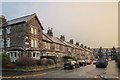
Dragon Terrace, Harrogate
Off Dragon Road, and also seen in Image
Image: © Derek Harper
Taken: 27 Dec 2013
0.01 miles
2
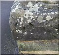
Harrogate, Dragon View
The benchmark and rivet are cut into the extreme left of the front garden wall of the property.
Image: © Mel Towler
Taken: 13 Jan 2022
0.04 miles
3
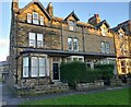
Harrogate, Dragon View
There is a benchmark and rivet cut into the extreme left of the front garden wall, the top wall stone, of this property.
Image: © Mel Towler
Taken: 13 Jan 2022
0.04 miles
4

Dragon Road, Harrogate
Getting towards sunset after rain.
Image: © Derek Harper
Taken: 27 Dec 2013
0.04 miles
5
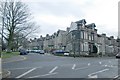
Mornington Crescent, Harrogate
For fans of the Radio 4 comedy show "I'm Sorry I Haven't A Clue", here's a picture of Mornington Crescent, but this one is in Harrogate! For more info on the radio show, visit
http://www.isihac.org.uk .
Image: © Kevin Hale
Taken: 18 Dec 2005
0.05 miles

7

Dragon Road, Harrogate
A reverse view of Image On the right is Smiths the Rink, a furniture store on the site of a roller skating rink.
Image: © Derek Harper
Taken: 27 Dec 2013
0.06 miles
8
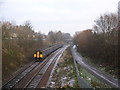
Sustrans 67 and Railway
On the right of the picture is the Dragon Road cycle route, designated as national route 67 by Sustrans. This runs from the Asda car park to Claro along the route of the railway, a third line was removed to enable this path. The route then continues along the two disused sides of the Bilton railway triangle to Starbeck and Knaresborough. The railway also travels through to Starbeck and Knaresborough by the third side of the triangle. The bridge ahead carries Skipton Road over the railway and cycle path. The picture is taken from the Dragon Road footbridge.
Image: © DS Pugh
Taken: 21 Dec 2006
0.06 miles
9
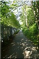
Cycle path along the railway
Linking the town centre with Claro.
Image: © DS Pugh
Taken: 8 Aug 2015
0.06 miles
10
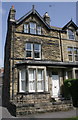
#38 Dragon Parade at Regent Grove junction
There is an OS benchmark Image on top of the wall angle
Image: © Roger Templeman
Taken: 24 May 2012
0.07 miles