IMAGES TAKEN NEAR TO
Emerald Close, HARROGATE, HG1 4QL
Introduction
This page details the photographs taken nearby to Emerald Close, HG1 4QL by members of the Geograph project.
The Geograph project started in 2005 with the aim of publishing, organising and preserving representative images for every square kilometre of Great Britain, Ireland and the Isle of Man.

There are currently over 7.5m images from over14,400 individuals and you can help contribute to the project by visiting https://www.geograph.org.uk
Image Map (Loading...)


Getting Data...Please wait
Leaflet Map data © OpenStreetMap
Images are licensed for reuse under creativecommons.org/licenses/by-sa/2.0
Notes
- Clicking on the map will re-center to the selected point.
- The higher the marker number, the further away the image location is from the centre of the postcode.
Image Listing (63 Images Found)
Images are licensed for reuse under creativecommons.org/licenses/by-sa/2.0
Image
Details
Distance
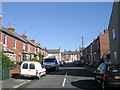
1
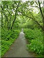
Cycle route off The Avenue, Starbeck
Following the route of the two-track North Eastern Railway line towards Thirsk that closed in 1969, this links to the Nidderdale Greenway at Bilton.
Image: © Stephen Craven
Taken: 8 Jul 2023
0.03 miles
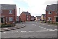
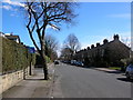
2
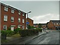
Emerald Close, off The Avenue, Starbeck
A modern housing development, its name inspired by Diamond Close nearby (which is part of the original early C20 housing in the area).
Image: © Stephen Craven
Taken: 8 Jul 2023
0.03 miles
3
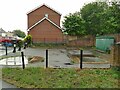
Water facility, The Avenue, Starbeck
I suspect this is a sewage pumping station, given the number of large access covers and the electrical cabinet that presumably controls submersible pumps.
Image: © Stephen Craven
Taken: 8 Jul 2023
0.04 miles
6
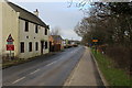
Bogs Lane, Starbeck
Travelling west towards Henshaws College.
Image: © Chris Heaton
Taken: 5 Jan 2015
0.10 miles
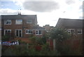
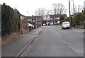
7
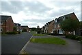
Houses on Rowan Close
Looking along a street of houses on the edge of Starbeck.
Image: © DS Pugh
Taken: 4 Jun 2023
0.10 miles
9
Starbeck
The Avenue, Starbeck. This road provides the last bit of access into Starbeck from the Harrogate to Starbeck cycle route using the old railway (behind).
Image: © DS Pugh
Taken: 31 Mar 2006
0.11 miles
10
Olive Way - looking towards Olive Walk
Image: © Betty Longbottom
Taken: 5 Apr 2017
0.12 miles