IMAGES TAKEN NEAR TO
Woodfield View, HARROGATE, HG1 4NB
Introduction
This page details the photographs taken nearby to Woodfield View, HG1 4NB by members of the Geograph project.
The Geograph project started in 2005 with the aim of publishing, organising and preserving representative images for every square kilometre of Great Britain, Ireland and the Isle of Man.

There are currently over 7.5m images from over14,400 individuals and you can help contribute to the project by visiting https://www.geograph.org.uk
Image Map (Loading...)


Getting Data...Please wait
Leaflet Map data © OpenStreetMap
Images are licensed for reuse under creativecommons.org/licenses/by-sa/2.0
Notes
- Clicking on the map will re-center to the selected point.
- The higher the marker number, the further away the image location is from the centre of the postcode.
Image Listing (150 Images Found)
Images are licensed for reuse under creativecommons.org/licenses/by-sa/2.0
Image
Details
Distance
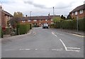
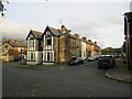
3
Woodfield Square - Woodfield Drive
Image: © Betty Longbottom
Taken: 28 Apr 2017
0.04 miles
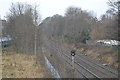
4
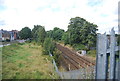
View across the York to Harrogate line
This view looks across the railway from the footbridge on the Nidderdale Greenway towards Grove Park Avenue and the streets running at right angles to it. These include Mafeking Street, Powell Street and Baden Street - names which suggest that they were built at the time of the Boer War.
Image: © Marathon
Taken: 13 Mar 2012
0.05 miles
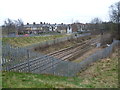
5
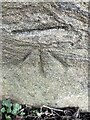
Cut mark - Grove Park Avenue - Harrogate (a)
Cut mark on Grove Park Avenue, Harrogate
Image: © Tez Exley
Taken: 13 Apr 2023
0.05 miles
6
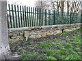
Cut mark - Grove Park Avenue - Harrogate (b)
Cut mark on Grove Park Avenue, Harrogate, on wall to railway embankment
Image: © Tez Exley
Taken: 13 Apr 2023
0.05 miles
7
Cut mark - Grove Park Avenue - Harrogate (c)
Cut mark on Grove Park Avenue, Harrogate, on wall to railway embankment. Cut mark is on the flat faced stone just to the right of the concrete plate holder
Image: © Tez Exley
Taken: 13 Apr 2023
0.05 miles
9
Mafeking Street, Harrogate
Mafeking Street is a short residential cul-de-sac in Harrogate.
Image: © Malc McDonald
Taken: 14 Oct 2021
0.06 miles
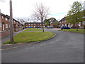
10
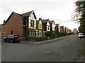
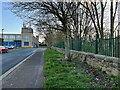
Grove Park Avenue, Harrogate
Grove Park Avenue is a residential road in Harrogate. It forms part of the royute of National Cycle Network route 67 as it passes through the town.
Image: © Malc McDonald
Taken: 14 Oct 2021
0.06 miles