IMAGES TAKEN NEAR TO
Crab Lane, HARROGATE, HG1 3BE
Introduction
This page details the photographs taken nearby to Crab Lane, HG1 3BE by members of the Geograph project.
The Geograph project started in 2005 with the aim of publishing, organising and preserving representative images for every square kilometre of Great Britain, Ireland and the Isle of Man.

There are currently over 7.5m images from over14,400 individuals and you can help contribute to the project by visiting https://www.geograph.org.uk
Image Map
Images are licensed for reuse under creativecommons.org/licenses/by-sa/2.0
Notes
- Clicking on the map will re-center to the selected point.
- The higher the marker number, the further away the image location is from the centre of the postcode.
Image Listing (81 Images Found)
Images are licensed for reuse under creativecommons.org/licenses/by-sa/2.0
Image
Details
Distance
1
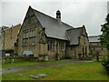
St John's pre-school
A former Sunday School still in educational use. Listed grade II (list entry 1294101). Circa 1847 (if that date is correct, it was built before the adjacent church itself), in Perpendicular style.
Image: © Stephen Craven
Taken: 8 Jul 2023
0.03 miles
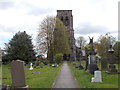
3
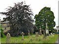
Copper beech tree in St John's churchyard
The church congregation is committed to developing the ecology of the churchyard and an information board describes the major churchyard trees. This one was planted to celebrate 200 years of Methodism (date not given; there are various significant dates in the history of the movement).
Image: © Stephen Craven
Taken: 8 Jul 2023
0.04 miles
4
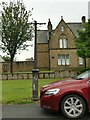
Old lamp post, Elm Tree Avenue
Listed grade II (list entry 1149480) and described as 'Good mid C19 lamp post with cast iron standard with trefoil arcading, ladder bars and Windsor lantern'. The lantern (which would originally have been gas-lit from the nearby gas works at New Park) has disappeared since it was listed in 1975. A church member told me of plans to install modern bollard lighting to the drive.
Image: © Stephen Craven
Taken: 8 Jul 2023
0.04 miles
5
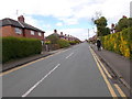
Elm Tree Avenue, off Bilton Lane
The road leading to St John's church was shown on the 1892 map but only in the 1920s was it conveyed by the landowner (William Sheepshanks) to church ownership.
Image: © Stephen Craven
Taken: 8 Jul 2023
0.04 miles
6
Harrogate, Bilton, St John's church
According to the OS benchmark database there is a cut mark on the south-east face of the church. After countless searches it hasn't been located. Is the entrance on the side of the church newer than the original structure, and is this now covering the benchmark?
Image: © Mel Towler
Taken: 2 Jan 2022
0.04 miles
7
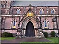
Harrogate, Bilton, St John's church
According to the OS benchmark database there is a cut mark on the south-east face of the church. After countless searches it hasn't been located.
Image: © Mel Towler
Taken: 2 Jan 2022
0.04 miles
8
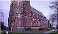
St John the Evangelist - viewed from Crab Lane
Image: © Betty Longbottom
Taken: 28 Apr 2017
0.05 miles
9
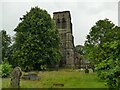
Tower of St John's church
The church of St John the Evangelist, Bilton is listed grade II* (list entry 1315827). It was built 1851-57 by Sir George Gilbert Scott in his usual Gothic Revival style.
Image: © Stephen Craven
Taken: 8 Jul 2023
0.05 miles
10
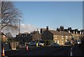
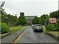
Junction in Bilton
Crab Lane forks off to the left from Bilton Lane, which is about to be closed for roadworks, hence the cones.
Image: © Derek Harper
Taken: 5 Apr 2013
0.05 miles