IMAGES TAKEN NEAR TO
Back Unity Grove, HARROGATE, HG1 2AL
Introduction
This page details the photographs taken nearby to Back Unity Grove, HG1 2AL by members of the Geograph project.
The Geograph project started in 2005 with the aim of publishing, organising and preserving representative images for every square kilometre of Great Britain, Ireland and the Isle of Man.

There are currently over 7.5m images from over14,400 individuals and you can help contribute to the project by visiting https://www.geograph.org.uk
Image Map
Images are licensed for reuse under creativecommons.org/licenses/by-sa/2.0
Notes
- Clicking on the map will re-center to the selected point.
- The higher the marker number, the further away the image location is from the centre of the postcode.
Image Listing (122 Images Found)
Images are licensed for reuse under creativecommons.org/licenses/by-sa/2.0
Image
Details
Distance
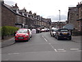
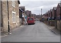
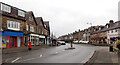
3
Grange Avenue
A side road between King's Road and Skipton Road.
Image: © DS Pugh
Taken: 29 Mar 2014
0.04 miles
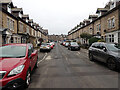
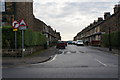
4
Unity Grove - viewed from Bilton Drive
Image: © Betty Longbottom
Taken: 28 Apr 2017
0.04 miles
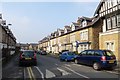
7
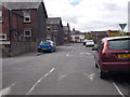
Bilton Drive - viewed from Unity Grove
Image: © Betty Longbottom
Taken: 28 Apr 2017
0.04 miles
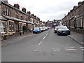
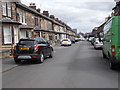
9
Kings Road, Harrogate
A close-up of the post box can be seen in Image
Image: © habiloid
Taken: 15 Feb 2023
0.06 miles
10
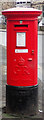
Post box, Kings Road, Harrogate
This post box can be seen in context in Image
Image: © habiloid
Taken: 15 Feb 2023
0.06 miles