IMAGES TAKEN NEAR TO
Commercial Street, HARROGATE, HG1 1TZ
Introduction
This page details the photographs taken nearby to Commercial Street, HG1 1TZ by members of the Geograph project.
The Geograph project started in 2005 with the aim of publishing, organising and preserving representative images for every square kilometre of Great Britain, Ireland and the Isle of Man.

There are currently over 7.5m images from over14,400 individuals and you can help contribute to the project by visiting https://www.geograph.org.uk
Image Map (Loading...)


Getting Data...Please wait
Leaflet Map data © OpenStreetMap
Images are licensed for reuse under creativecommons.org/licenses/by-sa/2.0
Notes
- Clicking on the map will re-center to the selected point.
- The higher the marker number, the further away the image location is from the centre of the postcode.
Image Listing (944 Images Found)
Images are licensed for reuse under creativecommons.org/licenses/by-sa/2.0
Image
Details
Distance
1
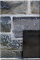
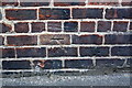
Benchmark on the Drill Hall, Commercial Street
Ordnance Survey cut mark benchmark described on the Bench Mark Database at http://www.bench-marks.org.uk/bm31686
Image: © Roger Templeman
Taken: 24 May 2012
0.01 miles
2
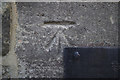
Cut Bench Mark, Commercial Street Drill Hall
Bench Mark Database: http://www.bench-marks.org.uk/bm31686
Image: © Mark Anderson
Taken: 31 Dec 2016
0.01 miles
3
Commercial Street Drill Hall
There is a cut bench mark on the wall to the left of the green door and a closer view can be seen here: Image
Image: © Mark Anderson
Taken: 31 Dec 2016
0.01 miles
4
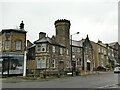
Drill Hall & Barracks - Commercial Street
Image: © Betty Longbottom
Taken: 25 Jan 2010
0.01 miles
5
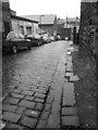
Back alley, Harrogate
This cobbled cul-de-sac off Bower Road, shown in black and white on a wet winter Saturday, is unnamed on the maps.
Image: © Derek Harper
Taken: 22 Dec 2012
0.02 miles
6
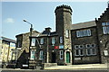
The Drill Hall, Commercial Street
There is an OS benchmark Image on a stone near the base of the turret
Image: © Roger Templeman
Taken: 24 May 2012
0.02 miles
7
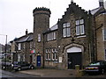
Cadet training centre, Commercial Street, Harrogate
A former drill hall Image now used by the Army Cadets and Air Training Corps.
Image: © Stephen Craven
Taken: 8 Jul 2023
0.02 miles
8
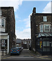
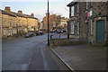
Alley between Commercial Street and Mayfield Grove
Bower Road runs along the foreground.
Image: © habiloid
Taken: 19 May 2019
0.02 miles
9
Benchmark on #31 Commercial Street
Ordnance Survey cut mark benchmark described on the Bench Mark Database at http://www.bench-marks.org.uk/bm43165
Image: © Roger Templeman
Taken: 24 May 2012
0.03 miles
10
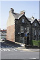
Junction of Commercial Road and Back Cheltenham Mount
There is an OS benchmark Image on the side of the house on the bricks of the Back Cheltenham Mount face
Image: © Roger Templeman
Taken: 24 May 2012
0.03 miles