IMAGES TAKEN NEAR TO
Rogers Square, HARROGATE, HG1 1HZ
Introduction
This page details the photographs taken nearby to Rogers Square, HG1 1HZ by members of the Geograph project.
The Geograph project started in 2005 with the aim of publishing, organising and preserving representative images for every square kilometre of Great Britain, Ireland and the Isle of Man.

There are currently over 7.5m images from over14,400 individuals and you can help contribute to the project by visiting https://www.geograph.org.uk
Image Map (Loading...)


Getting Data...Please wait
Leaflet Map data © OpenStreetMap
Images are licensed for reuse under creativecommons.org/licenses/by-sa/2.0
Notes
- Clicking on the map will re-center to the selected point.
- The higher the marker number, the further away the image location is from the centre of the postcode.
Image Listing (1014 Images Found)
Images are licensed for reuse under creativecommons.org/licenses/by-sa/2.0
Image
Details
Distance
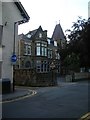
1
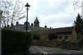
Belford Place
Looking towards the clock tower on the almshouses.
Image: © DS Pugh
Taken: 28 Mar 2021
0.00 miles
2
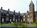
Rogers' Square [1]
Of the 14 almshouses, 12 were built in 1868 and given by George Rogers. Listed grade II, details are at: https://www.historicengland.org.uk/listing/the-list/list-entry/1149503 See also Image
Image: © Michael Dibb
Taken: 9 Jun 2016
0.01 miles
3
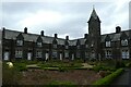
Rogers' Square
Almshouses opposite St. Peter's School.
Image: © DS Pugh
Taken: 28 Mar 2021
0.01 miles
5
Belmont Road
Part of Belmont Road, home to St. Peter's School. The school is in a converted cottage hospital.
Image: © DS Pugh
Taken: 7 Jul 2007
0.02 miles
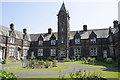
6
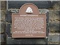
Rogers' Square [2]
Information board. See also Image
Image: © Michael Dibb
Taken: 9 Jun 2016
0.02 miles
7
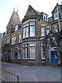
St. Peter's School
St. Peter's primary school on Belford Road. This is a converted cottage hospital. It stands opposite Roger's Square.
Image: © DS Pugh
Taken: 7 Jul 2007
0.02 miles
8
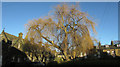
Willow, Belford Place, Harrogate
Seen from Belford Road. On the left are Roger's Almshouses https://historicengland.org.uk/listing/the-list/list-entry/1149503 . On the right is Albert Terrace https://historicengland.org.uk/listing/the-list/list-entry/1149502 .
Image: © Derek Harper
Taken: 1 Jan 2019
0.02 miles
9
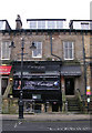
Carringtons Nightclub - Station Parade
Image: © Betty Longbottom
Taken: 14 Dec 2009
0.03 miles
10
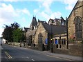
Belmont Road
St. Peter's School and St. Paul's Church, situated on Belmont Road.
Image: © DS Pugh
Taken: 28 Jul 2007
0.03 miles