IMAGES TAKEN NEAR TO
Sheffield Road, HOLMFIRTH, HD9 7TP
Introduction
This page details the photographs taken nearby to Sheffield Road, HD9 7TP by members of the Geograph project.
The Geograph project started in 2005 with the aim of publishing, organising and preserving representative images for every square kilometre of Great Britain, Ireland and the Isle of Man.

There are currently over 7.5m images from over14,400 individuals and you can help contribute to the project by visiting https://www.geograph.org.uk
Image Map
Images are licensed for reuse under creativecommons.org/licenses/by-sa/2.0
Notes
- Clicking on the map will re-center to the selected point.
- The higher the marker number, the further away the image location is from the centre of the postcode.
Image Listing (10 Images Found)
Images are licensed for reuse under creativecommons.org/licenses/by-sa/2.0
Image
Details
Distance
1
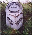
Old Milestone, A616, Sheffield Road, Hepworth
Near junction with Gate Head Lane. Located on the South side of road, in narrow verge opposite Gatehead Methodist Chapel, near bend up hill. Metal plate attached to stone post, Brayshaw & Booth casting design, erected by Wadsley & Langsett - New Mill District turnpike trust, 19th century.
Inscription reads: SHEFFIELD / 18 MILES // HUDDERSFIELD / 8½ MILES // NEW MILL DISTRICT / ROAD / HEPWORTH // BRAYSHAW & BOOTH / MAKERS / LIVERSEDGE
Grade II listed by Historic England. see https://historicengland.org.uk/listing/the-list/list-entry/1228481
Milestone Society National ID: YW_SFHU18
Image: © Christine Minto
Taken: Unknown
0.15 miles
2
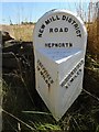
Old milestone
In 2017 this West Riding CC milestone from 1893/94 had lost most of its paint. It is not known who has painted it but it certainly looks much smarter. It is nearly opposite Gate Head Lane and Gatehead Methodist Chapel which on the day of this photo was 'SOLD'. After passing the milestone going southwards there is a sharp left bend and a short distance up the road is a tollhouse from the Wadsley and Langsett, Holmfirth District, turnpike first enacted in 1823, closed in 1879. The milestone is Grade II listed 1191204.
Image: © Chris Minto
Taken: 11 Aug 2022
0.15 miles
3
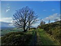
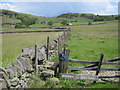
Mill Shaw Lane, Hepworth
A bridleway that skirts around Cheese Gate Nab, the hill on the right.
Image: © Humphrey Bolton
Taken: 20 Apr 2009
0.16 miles
5
Footpath from Snug Lane to Sheffield Road, Hepworth
Image: © Chris Wimbush
Taken: 11 Jun 2011
0.20 miles
6
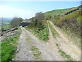
Upper Mill Shaw, Hepworth
Mill Shaw Lane, a bridleway, goes to the right.
Image: © Humphrey Bolton
Taken: 20 Apr 2009
0.20 miles
8
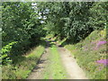
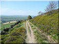
Track along Cheese Gate Nab
Looking westward.
Image: © Peter Wood
Taken: 23 Jul 2017
0.23 miles
9
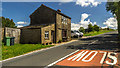
Sheffield Road
Cottage alongside the A616 Sheffield Road. For further details see Image
Image: © Peter McDermott
Taken: 27 Jun 2015
0.24 miles