IMAGES TAKEN NEAR TO
Thongsbridge, HOLMFIRTH, HD9 7TD
Introduction
This page details the photographs taken nearby to HD9 7TD by members of the Geograph project.
The Geograph project started in 2005 with the aim of publishing, organising and preserving representative images for every square kilometre of Great Britain, Ireland and the Isle of Man.

There are currently over 7.5m images from over14,400 individuals and you can help contribute to the project by visiting https://www.geograph.org.uk
Image Map
Images are licensed for reuse under creativecommons.org/licenses/by-sa/2.0
Notes
- Clicking on the map will re-center to the selected point.
- The higher the marker number, the further away the image location is from the centre of the postcode.
Image Listing (46 Images Found)
Images are licensed for reuse under creativecommons.org/licenses/by-sa/2.0
Image
Details
Distance
1
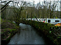
The River Holme passing Holme Valley Camping and Caravan Park
The caravan park is on the site of Lower Mytholm Bridge Mills.
Image: © Humphrey Bolton
Taken: 10 Dec 2020
0.03 miles
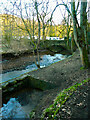
2
Bridge on Lancaster Lane over the River Holme near Brockholes
The caravan site is where Lower Mytholm Bridge Mills were. Originally the access to the mills was from Woodhead Road and from Mytholm Bridge, but some time in the second half of the 19C a way was made from Brockholes, and this bridge constructed.
Image: © Humphrey Bolton
Taken: 10 Dec 2020
0.03 miles
3
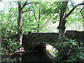
Bridge over the River Holme.
Lovely setting despite being quite a built up area.
Image: © steven ruffles
Taken: 12 Jun 2015
0.04 miles
4
River Holme and a tail race exit, Mytholm Bridge, Honley
This is the downstream end of the tail race from Lower Mytholm Bridge Mill, which has been demolished and a caravan park made on the site. The tail race does not discharge directly to the river, but into a channel alongside. The reason is not known, but it might be that the channel could be dammed to make a pond in which lengths of cloth could be washed.
Image: © Humphrey Bolton
Taken: 27 Feb 2021
0.06 miles
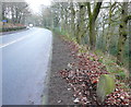
5
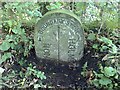
Old Boundary Marker by the A6024, Woodhead Road, Holme Valley Parish
Parish Boundary Marker by the A6024, in parish of Holme Valley (Kirklees District), Woodhead Road, near Hagg Wood Quarry.
Surveyed
Milestone Society National ID: YW_HONHOL01pb
Image: © Milestone Society
Taken: Unknown
0.10 miles
6
Honley / Holmfirth boundary stone, Woodhead Road
See Image] for details.
Image: © Humphrey Bolton
Taken: 4 Dec 2014
0.10 miles
7
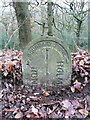
Boundary stone, Woodhead Road
This stone was puzzling at first. It is listed, Grade II, and is called a ward boundary stone, mid-19C. It might be on a ward boundary now, but wasn't in the 19C. The boundary between Honley and Holmfirth was Hagg Dike, at Thongsbridge to the south. A boundary stone on the main road, over this stream, is first shown on the 1904 revision of the 1:2500 map, soon after the two places became urban district councils. There was a change of boundary in 1912, when the southern part of Honley was transferred to Holmfirth. The new boundary intersected Woodhead Road at this point. The 1932 revision of the 1:2500 map shows a boundary stone here but not over Hagg Dike, so I think this was the late 19C or early 20C stone, and that it was moved here when the boundary changed.
Image: © Humphrey Bolton
Taken: 4 Dec 2014
0.10 miles
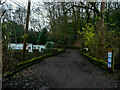
8
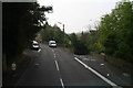
A616 turn-off to Mytholm Bridge and Thongsbridge
Image: © Chris
Taken: 11 Sep 2014
0.10 miles
9
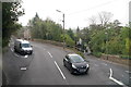
A616 turn-off to Mytholm Bridge and Thongsbridge
Image: © Chris
Taken: 11 Sep 2014
0.10 miles
10
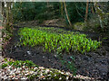
Small millpond in Hagg Wood, Honley
This pond is fed by springs, and from here water was piped to Lower Mytholm Bridge Mill. It will be worth revisiting in the summer when the iris plants are flowering.
Image: © Humphrey Bolton
Taken: 27 Feb 2021
0.10 miles