IMAGES TAKEN NEAR TO
Stoney Bank Lane, HOLMFIRTH, HD9 7LZ
Introduction
This page details the photographs taken nearby to Stoney Bank Lane, HD9 7LZ by members of the Geograph project.
The Geograph project started in 2005 with the aim of publishing, organising and preserving representative images for every square kilometre of Great Britain, Ireland and the Isle of Man.

There are currently over 7.5m images from over14,400 individuals and you can help contribute to the project by visiting https://www.geograph.org.uk
Image Map
Images are licensed for reuse under creativecommons.org/licenses/by-sa/2.0
Notes
- Clicking on the map will re-center to the selected point.
- The higher the marker number, the further away the image location is from the centre of the postcode.
Image Listing (23 Images Found)
Images are licensed for reuse under creativecommons.org/licenses/by-sa/2.0
Image
Details
Distance
1
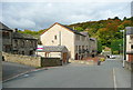
Stony Bank Lane, New Mill
The new houses are where the mill used to be. Presumably the road was or is unadopted, as it is part of Holmfirth FP48. On the 'Explorer' map the footpath is shown going straight on when it reaches the new houses, but you have to go left past the pair of 'semis' and then right.
Image: © Humphrey Bolton
Taken: 14 Oct 2015
0.11 miles
2
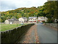
Houses on the Stony Bank Mill site, New Mill
Holmfirth FP48 goes down the street. According to the 1893 1:2500 map the houses on the left were attached to one of the mill buildings.
Image: © Humphrey Bolton
Taken: 14 Oct 2015
0.13 miles
3
Tenter Hill Lane, New Mill
This is one of the old lanes of Wooldale, and is part of Holmfirth Bridleway 51.
Image: © Humphrey Bolton
Taken: 14 Oct 2015
0.14 miles
5
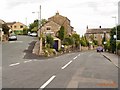
Wooldale
Junction of Pell Lane and Lower Town End at Wooldale just below the Quaker Meeting House
Image: © Stanley Walker
Taken: 16 Aug 2006
0.14 miles
6
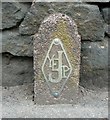
Utility marker post, New Mill Road
A rather stylish design. YE must surely be for Yorkshire Electricity, anddoes JP stand for 'Junction Point'?
Image: © Humphrey Bolton
Taken: 14 Apr 2009
0.14 miles
7
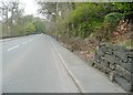
New Mill Road
Showing the position of the marker post in Image
Image: © Humphrey Bolton
Taken: 14 Apr 2009
0.14 miles
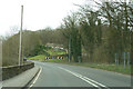
8
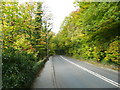
Huddersfield Road, Thurstonland
Sinking Wood is on the right.
Image: © Humphrey Bolton
Taken: 14 Oct 2015
0.14 miles
9
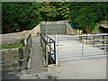
Footbridge on Holmfirth FP48, New Mill
The bridge crosses New Mill Dike into Thurstonland. The waymarks indicate a footpath to the left, which goes down the valley, and one to the right, which is climbs up to Huddersfield Road and Sinking Wood. The land behind the wall and trees was New Mill Sewage Works.
Image: © Humphrey Bolton
Taken: 14 Oct 2015
0.15 miles
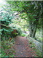
10
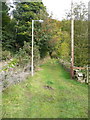
Holmfirth FP48, Thurstonland
The footpath is on a broad grassy track and has a street lamp.
Image: © Humphrey Bolton
Taken: 14 Oct 2015
0.16 miles