IMAGES TAKEN NEAR TO
The Maltings, HOLMFIRTH, HD9 7JW
Introduction
This page details the photographs taken nearby to The Maltings, HD9 7JW by members of the Geograph project.
The Geograph project started in 2005 with the aim of publishing, organising and preserving representative images for every square kilometre of Great Britain, Ireland and the Isle of Man.

There are currently over 7.5m images from over14,400 individuals and you can help contribute to the project by visiting https://www.geograph.org.uk
Image Map
Images are licensed for reuse under creativecommons.org/licenses/by-sa/2.0
Notes
- Clicking on the map will re-center to the selected point.
- The higher the marker number, the further away the image location is from the centre of the postcode.
Image Listing (34 Images Found)
Images are licensed for reuse under creativecommons.org/licenses/by-sa/2.0
Image
Details
Distance
1
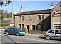
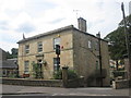
Hunter's Lodge, Huddersfield Road, New Mill, Fulstone township
There is a pair of antlers over the name plaque. Despite the name this appears to be a pair of houses.
Image: © Humphrey Bolton
Taken: 5 Apr 2007
0.02 miles
2
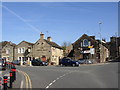
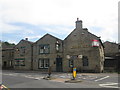
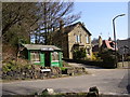
The White Hart, Huddersfield Road, New Mill, Fulstone township
Taken from the main road crossroads, Huddersfield Road to the left, Penistone Road steeply up to the right.
Image: © Humphrey Bolton
Taken: 5 Apr 2007
0.02 miles
3
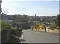
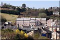
View of New Mill from Sude Hill, Fulstone township
A hamlet developed at the crossing of two turnpike roads, and this became a small industrial town during the 19C. New Mill UDC was formed in 1895 from the civil parishes of Fulstone, Hepworth and Scholes. It was abolished in 1938 and most of the area added to Holmfirth UD.
Image: © Humphrey Bolton
Taken: 5 Apr 2007
0.02 miles
7
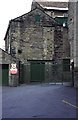
Moorbrook Mill, New Mills
Now demolished and replaced by housing. The view direction and photographer position are best guesses. I had already posted this mill from a different direction - Image
Image: © Chris Allen
Taken: 19 Aug 1995
0.04 miles
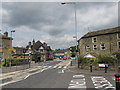
8
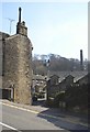
Water Row, off Penistone Road, New Mill, Fulstone township
This narrow lane is older than the turnpike roads, and goes across the Sheffield Road and New Mill Dike to join the road to Totties.
Image: © Humphrey Bolton
Taken: 5 Apr 2007
0.06 miles
9
New housing at New Mill
Residential development on the site of Moorhouse & Brookes' textile mill has been demolished and a new housing development built on the site.
Image: © Graham Hogg
Taken: 28 Mar 2012
0.07 miles
10
Barber's shop, Huddersfield Road, New Mill, Fulstone township
Image: © Humphrey Bolton
Taken: 5 Apr 2007
0.07 miles