IMAGES TAKEN NEAR TO
New Mill, HOLMFIRTH, HD9 7HH
Introduction
This page details the photographs taken nearby to HD9 7HH by members of the Geograph project.
The Geograph project started in 2005 with the aim of publishing, organising and preserving representative images for every square kilometre of Great Britain, Ireland and the Isle of Man.

There are currently over 7.5m images from over14,400 individuals and you can help contribute to the project by visiting https://www.geograph.org.uk
Image Map
Images are licensed for reuse under creativecommons.org/licenses/by-sa/2.0
Notes
- Clicking on the map will re-center to the selected point.
- The higher the marker number, the further away the image location is from the centre of the postcode.
Image Listing (16 Images Found)
Images are licensed for reuse under creativecommons.org/licenses/by-sa/2.0
Image
Details
Distance
1
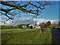
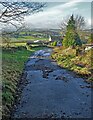
Holme House Lane, Fulstone, New Mill
This sunken lane must surely be an ancient packhorse track.
Image: © Humphrey Bolton
Taken: 14 Jun 2020
0.09 miles
2
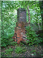
Remains of Sally Wood Colliery
This was one of several small coal mines in this area. All that I could find above ground level was this chimney, in which there is a fireplace and over it what looks like an oven.
Image: © Humphrey Bolton
Taken: 14 Jun 2020
0.10 miles
3
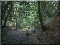
Gate on footpath off Holme House Lane, Fulstone, New Mill
This path goes through the grounds of Lower Holme House and then climbs up to Hirst Lane, passing through a delightful woodland of oak, birch and rowan trees.
Image: © Humphrey Bolton
Taken: 14 Jun 2020
0.11 miles
4
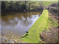
Mill dam, New Mill, Fulstone township
This is seen from Penistone Road. It existed in 1850 and appears to have supplied Sude Hill Mills, as OS maps show a water channel heading in that direction.
Image: © Humphrey Bolton
Taken: 5 Apr 2007
0.16 miles
6
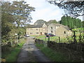
House, Sude Hill, New Mill, Fulstone township
This four-storey house has blocked taking-in doors to the upper three storeys, so probably a warehouse originally, with a weaving workshop on the top floor.
Image: © Humphrey Bolton
Taken: 5 Apr 2007
0.20 miles
8
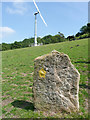
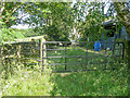
Ancient and modern, Lower Holme House, Fulstone, New Mill
I joked that this must be a prehistoric waymark stone, although I suspect that it was put here specially as something to put the yellow public footpath waymark arrowhead on.
Image: © Humphrey Bolton
Taken: 14 Jun 2020
0.20 miles
9

Scaly Gate from the Holme House Lane junction, Fulstone, New Mill
The lane is surfaced as far as the entrance to Far High Bank Farm
Image: © Humphrey Bolton
Taken: 14 Jun 2020
0.21 miles