IMAGES TAKEN NEAR TO
Summer View, HD9 7FH
Introduction
This page details the photographs taken nearby to Summer View, HD9 7FH by members of the Geograph project.
The Geograph project started in 2005 with the aim of publishing, organising and preserving representative images for every square kilometre of Great Britain, Ireland and the Isle of Man.

There are currently over 7.5m images from over14,400 individuals and you can help contribute to the project by visiting https://www.geograph.org.uk
Image Map
Images are licensed for reuse under creativecommons.org/licenses/by-sa/2.0
Notes
- Clicking on the map will re-center to the selected point.
- The higher the marker number, the further away the image location is from the centre of the postcode.
Image Listing (17 Images Found)
Images are licensed for reuse under creativecommons.org/licenses/by-sa/2.0
Image
Details
Distance
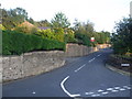
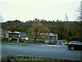
2
Cut benchmark on New Mill Road
This is on the wall on the northwest side of the road
Image: © John Slater
Taken: 26 Jul 2012
0.14 miles
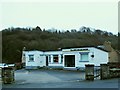
3
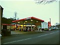
MURCO filling station, Huddersfield Road, Holmfirth
At this time when petrol prices were falling and most garages and supermarkets selling at under £1 a litre, this one was charging 105.9 pence. In a recent forum discussion on this site, "GHo" explained using industry inside knowledge that "smaller companies such as Murco cannot get the same economies of scale or cross-subsidy that the larger ones get. Also, the stuff sold at supermarkets is an inferior product therefore can be sold cheaper."
Image: © Stephen Craven
Taken: 16 Jan 2016
0.17 miles
4
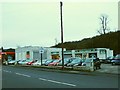
MOT testing station, Huddersfield Road, Holmfirth
Trading as JPA Motor Co. Ltd.
Image: © Stephen Craven
Taken: 16 Jan 2016
0.17 miles
5
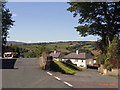
Town End
Junction of Bank Lane and Cliffe Road at Town End overlooking Upperthong
Image: © Stanley Walker
Taken: 25 Aug 2006
0.17 miles
6
The Mensroom, Huddersfield Road, Holmfirth
A barbers (or as they advertise it, men's grooming service).
Image: © Stephen Craven
Taken: 16 Jan 2016
0.17 miles
7
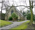
St Andrew's Church, Thongsbridge, Wooldale
A typical late Victorian church in Gothic style with lancet windows and a belfry.
Image: © Humphrey Bolton
Taken: 6 Mar 2008
0.19 miles
8
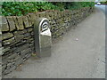
Old milestone
On a bend on the south side of the A635 between Holmfirth and New Mills is this 19C West Riding CC milestone. This area is called Wooldale and that name is on the top section. Left face - HOLMFIRTH/1 MILE, right face - DENBY/DALE/5¾ MILES/CAWTHORNE/9 MILES/BARNSLEY/13 MILES. The foundry name, BRAYSHAW & BOOTH/LIVERSEDGE is on the bevel. Grade II listed 1313589. It is in need of a clean and possible repaint.
Image: © Chris Minto
Taken: 12 Jun 2022
0.19 miles
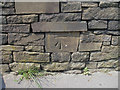
9

Old Milestone by the A635, New Mill Road, Holme Valley parish
Metal plate attached to stone post by the A635, in parish of HOLME VALLEY (KIRKLEES District), New Mill Road, Wooldale, between Holmfirth and New Mill, on narrow verge, on right angled bend in road, on South side of road. Brayshaw & Booth iron casting, erected by the County Council in the 19th century.
Inscription reads:-
: HOLMFIRTH / 1 MILE : : GREENFIELD & SHEPLEY / LANE HEAD / ROAD / WOOLDALE : : DENBY / DALE / 5¾ MILES / CAWTHORNE / 9 MILES / BARNSLEY / 13 MILES :
Maker:-
: BRAYSHAW & BOOTH / MAKERS / LIVERSEDGE :
Grade II listed.
List Entry Number: 1313589 https://historicengland.org.uk/listing/the-list/list-entry/1313589
Milestone Society National ID: YW_GFSLH11.
Image: © C Minto
Taken: 1 Aug 2001
0.19 miles
10
Holme Valley Police Station
Opposite the memorial hospital.
Image: © Stephen Craven
Taken: 16 Jan 2016
0.19 miles