IMAGES TAKEN NEAR TO
Weavers Mill Way, HOLMFIRTH, HD9 7FB
Introduction
This page details the photographs taken nearby to Weavers Mill Way, HD9 7FB by members of the Geograph project.
The Geograph project started in 2005 with the aim of publishing, organising and preserving representative images for every square kilometre of Great Britain, Ireland and the Isle of Man.

There are currently over 7.5m images from over14,400 individuals and you can help contribute to the project by visiting https://www.geograph.org.uk
Image Map
Images are licensed for reuse under creativecommons.org/licenses/by-sa/2.0
Notes
- Clicking on the map will re-center to the selected point.
- The higher the marker number, the further away the image location is from the centre of the postcode.
Image Listing (19 Images Found)
Images are licensed for reuse under creativecommons.org/licenses/by-sa/2.0
Image
Details
Distance
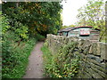
1
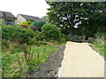
Stile and gate on Holmfirth Bridleway 51, Thongsbridge, Wooldale
The path has been surfaced with light-coloured broken stone in conjunction with a new housing development. No doubt it will darken eventually and be colonised by grass and other plants.
Image: © Humphrey Bolton
Taken: 14 Oct 2015
0.04 miles
2
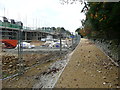
Holmfirth Bridleway 51 alongside new housing development, Thongsbridge, Wooldale
The bridleway is being kept separate from the housing estate road and has been surfaced with broken stone.
Image: © Humphrey Bolton
Taken: 14 Oct 2015
0.05 miles
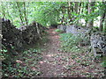
3
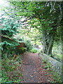
Tenter Hill Lane, New Mill
This is one of the old lanes of Wooldale, and is part of Holmfirth Bridleway 51.
Image: © Humphrey Bolton
Taken: 14 Oct 2015
0.06 miles
4
Tenter Hill Lane, New Mill
This is one of the old lanes of Wooldale, and is part of Holmfirth Bridleway 51.
Image: © Humphrey Bolton
Taken: 14 Oct 2015
0.11 miles
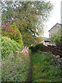
5
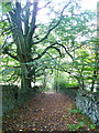
Sycamore Lane, Thongsbridge, Wooldale
This is part of Holmfirth Bridleway 51. On the right there is a shed made from an old railway wagon.
Image: © Humphrey Bolton
Taken: 14 Oct 2015
0.12 miles
6
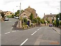
Wooldale
Junction of Pell Lane and Lower Town End at Wooldale just below the Quaker Meeting House
Image: © Stanley Walker
Taken: 16 Aug 2006
0.13 miles
8
Sycamore Lane, Thongsbridge, Wooldale
This is one of the old lanes between the present-day roads. It is part of Holmfirth Bridleway 51.
Image: © Humphrey Bolton
Taken: 14 Oct 2015
0.14 miles
9
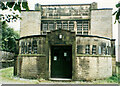
Sunday School, Holmfirth Road, Lydgate, New Mill
This is the Oliver Heywood Memorial Sunday School, built in 1910. The architects were Edgar Wood and James Henry Sellers.
Image: © Humphrey Bolton
Taken: 17 Sep 2000
0.20 miles
10
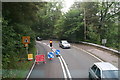
Roadworks on the A616 between Thongsbridge and New Mill
Image: © Chris
Taken: 11 Sep 2014
0.20 miles