IMAGES TAKEN NEAR TO
Norridge Bottom, HOLMFIRTH, HD9 7BB
Introduction
This page details the photographs taken nearby to Norridge Bottom, HD9 7BB by members of the Geograph project.
The Geograph project started in 2005 with the aim of publishing, organising and preserving representative images for every square kilometre of Great Britain, Ireland and the Isle of Man.

There are currently over 7.5m images from over14,400 individuals and you can help contribute to the project by visiting https://www.geograph.org.uk
Image Map
Images are licensed for reuse under creativecommons.org/licenses/by-sa/2.0
Notes
- Clicking on the map will re-center to the selected point.
- The higher the marker number, the further away the image location is from the centre of the postcode.
Image Listing (419 Images Found)
Images are licensed for reuse under creativecommons.org/licenses/by-sa/2.0
Image
Details
Distance
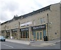
1
Ryder & Dutton - Huddersfield Road
Image: © Betty Longbottom
Taken: 11 Aug 2010
0.00 miles
2
Bamboo Forest Takeaway - Huddersfield Road
Image: © Betty Longbottom
Taken: 11 Aug 2010
0.01 miles
3
Rhythm & Booze - Huddersfield Road
Image: © Betty Longbottom
Taken: 11 Aug 2010
0.01 miles
4
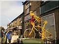
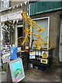
Skeleton rider
A different twist on the many yellow bikes along the Tour de France route is this one in Holmfirth.
Image: © Stephen Craven
Taken: 16 Jan 2016
0.01 miles
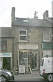
5
The Linen Cupboard - Huddersfield Road
Image: © Betty Longbottom
Taken: 11 Aug 2010
0.01 miles
6
Country Collections - Huddersfield Road
Image: © Betty Longbottom
Taken: 11 Aug 2010
0.01 miles
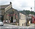
7
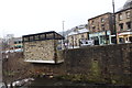
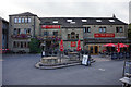
Holmfirth - Market Square and Hanging Bus Shelter
View across river from the Picturedrome.
Image: © Alan Heardman
Taken: 20 Mar 2013
0.02 miles
8
Recycle sculpture, Huddersfield Road
Image: © Humphrey Bolton
Taken: 8 Jul 2014
0.02 miles