IMAGES TAKEN NEAR TO
New Mill Road, HOLMFIRTH, HD9 7AZ
Introduction
This page details the photographs taken nearby to New Mill Road, HD9 7AZ by members of the Geograph project.
The Geograph project started in 2005 with the aim of publishing, organising and preserving representative images for every square kilometre of Great Britain, Ireland and the Isle of Man.

There are currently over 7.5m images from over14,400 individuals and you can help contribute to the project by visiting https://www.geograph.org.uk
Image Map
Images are licensed for reuse under creativecommons.org/licenses/by-sa/2.0
Notes
- Clicking on the map will re-center to the selected point.
- The higher the marker number, the further away the image location is from the centre of the postcode.
Image Listing (24 Images Found)
Images are licensed for reuse under creativecommons.org/licenses/by-sa/2.0
Image
Details
Distance
1
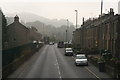
Dark September morning, A616 through Brockholes
Image: © Chris
Taken: 11 Sep 2014
0.01 miles
2
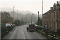
Darky, misty September morning on the A616, Brockholes
"Freshly Clicked" home delivery service at work.
Image: © Chris
Taken: 11 Sep 2014
0.02 miles
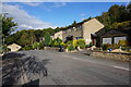
3
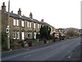
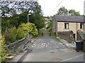
New Mill Road, Honley
This was a new turnpike road, the Wadsley and Langsett Trust, in 1804-5. The mileposts are from Huddersfield to Sheffield. This photo shows a row of probably late 19C houses associated with the industry nearby, and later houses beyond. The road is built on a straight alignment on the flat valley floor, hence the speed camera warnings (the police radar car was in action today, but I was crawling along looking for something to photograph!).
Image: © Humphrey Bolton
Taken: 29 Nov 2005
0.05 miles
4
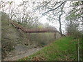
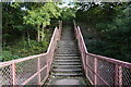
Footbridge over the railway northwest of Brockholes station
Image: © John Slater
Taken: 24 Apr 2016
0.19 miles
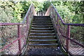
7
Smithy Place Lane
Stone built houses close to the River Holme.
Image: © Graham Hogg
Taken: 28 Mar 2012
0.20 miles
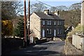
8
The old bridge at Smithy Place, Honley
This has now been replaced by a modern bridge to the SE, from which the arch of the old bridge can be seen (but best photographed in winter as it is obscured by tree-leaves). The 'slow' marking is still visible on the road surface.
Image: © Humphrey Bolton
Taken: 12 Oct 2006
0.20 miles
9
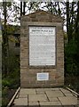
Toll board, Smithy Place, Honley
This is from the former Smithy Place turnpike. It gives tolls for animals and vehicles in great detail, and includes mechanically propelled vehicles at 1/- per wheel. A car would be 4/-, a large sum in the mid-20C, worth several pounds today.
Image: © Humphrey Bolton
Taken: 12 Oct 2006
0.20 miles