IMAGES TAKEN NEAR TO
Oldfield Road, HOLMFIRTH, HD9 6RN
Introduction
This page details the photographs taken nearby to Oldfield Road, HD9 6RN by members of the Geograph project.
The Geograph project started in 2005 with the aim of publishing, organising and preserving representative images for every square kilometre of Great Britain, Ireland and the Isle of Man.

There are currently over 7.5m images from over14,400 individuals and you can help contribute to the project by visiting https://www.geograph.org.uk
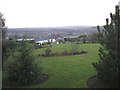
Image Map
Images are licensed for reuse under creativecommons.org/licenses/by-sa/2.0
Notes
- Clicking on the map will re-center to the selected point.
- The higher the marker number, the further away the image location is from the centre of the postcode.
Image Listing (6 Images Found)
Images are licensed for reuse under creativecommons.org/licenses/by-sa/2.0
Image
Details
Distance
1
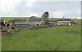
Carlin Farm, Oldfield Road
Viewed from Upper Hagg Road
Image: © Alan Longbottom
Taken: 17 Jul 2010
0.03 miles
2

Carlin Farm - Oldfield Lane - viewed from Upper Hagg Road
Image: © Betty Longbottom
Taken: 17 Jul 2010
0.03 miles
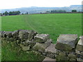
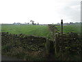
3
Public footpath from Oldfield road.
Walking in the Holme valley
Image: © steven ruffles
Taken: 14 Jul 2015
0.04 miles
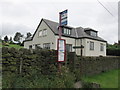
4
House on Oldfield Road
A large, well-tended back garden.
Image: © John Illingworth
Taken: 11 Jan 2006
0.04 miles
6
Footpath towards Netherthong leaving Long Lane
Image: © John Slater
Taken: 8 Oct 2014
0.23 miles