IMAGES TAKEN NEAR TO
New Mill Road, HOLMFIRTH, HD9 6QA
Introduction
This page details the photographs taken nearby to New Mill Road, HD9 6QA by members of the Geograph project.
The Geograph project started in 2005 with the aim of publishing, organising and preserving representative images for every square kilometre of Great Britain, Ireland and the Isle of Man.

There are currently over 7.5m images from over14,400 individuals and you can help contribute to the project by visiting https://www.geograph.org.uk
Image Map
Images are licensed for reuse under creativecommons.org/licenses/by-sa/2.0
Notes
- Clicking on the map will re-center to the selected point.
- The higher the marker number, the further away the image location is from the centre of the postcode.
Image Listing (20 Images Found)
Images are licensed for reuse under creativecommons.org/licenses/by-sa/2.0
Image
Details
Distance
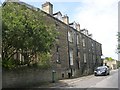
1
Near 18, Banks Road
Ironwork by Henry Brook and Co. Ltd. This firm closed down in 2002 after being in operation for over 150 years. Note the slanting letters in parts of the name
Image: © Alan Longbottom
Taken: 17 Jul 2010
0.10 miles
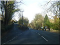
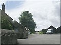
2
Parting of the Ways!
The road to the right leads to Woodhead Road, the one to the left is a continuation of Banks Road.
Image: © Betty Longbottom
Taken: 17 Jul 2010
0.11 miles
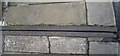
3
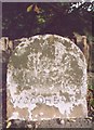
Old Milestone by the A6024, Woodhead Road, Honley
Milestone by the A6024, in parish of Holme Valley (Kirklees District), Woodhead Road, Honley, opposite junction with Far End Lane, near lamppost LP22.
Inscription reads:-
4 MILES
TO
HUDDERSFIELD
WOODHEAD
(9½)
Grade II listed.
List Entry Number: 1229755 https://historicengland.org.uk/listing/the-list/list-entry/1229755
Milestone Society National ID: YW_HUWH04
Image: © Milestone Society
Taken: Unknown
0.11 miles
4
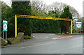
Entrance to Hope Bank Works
There was an open day in January 2014, and the web page included: "Come and look at the new space dedicated to the people of the Holme Valley and home of Hade Edge Academy of Music. If you are interested in Music, Art, Crafts, Knitting, Cooking, Growing…… or you just want coffee and cake in a friendly place then pop down." The bright yellow gantry seems to be recent, as it was not in the photograph on the web page.
Image: © Humphrey Bolton
Taken: 4 Dec 2014
0.12 miles
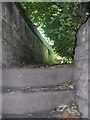
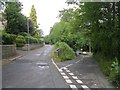
6
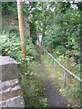
Footpath from Banks Road down to Woodhead Road
Image: © Betty Longbottom
Taken: 17 Jul 2010
0.13 miles
8
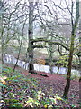
Beech tree in Honley Wood
The name 'Honley Wood' is perhaps a bit misleading, as it does not appear on old maps and the wood is very small, whilst Honley Wood towards Meltham to the west is large and well-known. It is owned by the Woodland Trust, who were given it by The Huddersfield Photographic and Antiquarian Society on the 18th March 1988. The public have free access, and it is shown as 'access' land on the 1:25000 map. There is a steep slippery slope down to the riverside, and the path that was created has become overgrown. This beech tree is mentioned in the management plan ( http://www.woodlandtrust.org.uk/woodfile/448/management-plan.pdf?cb=7589c2e02eaf4a07b67cbd3afa113129 ). There is a wooden platform in the tree, probably not installed by the Trust.
Image: © Humphrey Bolton
Taken: 4 Dec 2014
0.13 miles