IMAGES TAKEN NEAR TO
Scotgate Road, HOLMFIRTH, HD9 6JQ
Introduction
This page details the photographs taken nearby to Scotgate Road, HD9 6JQ by members of the Geograph project.
The Geograph project started in 2005 with the aim of publishing, organising and preserving representative images for every square kilometre of Great Britain, Ireland and the Isle of Man.

There are currently over 7.5m images from over14,400 individuals and you can help contribute to the project by visiting https://www.geograph.org.uk
Image Map
Images are licensed for reuse under creativecommons.org/licenses/by-sa/2.0
Notes
- Clicking on the map will re-center to the selected point.
- The higher the marker number, the further away the image location is from the centre of the postcode.
Image Listing (166 Images Found)
Images are licensed for reuse under creativecommons.org/licenses/by-sa/2.0
Image
Details
Distance
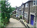
2
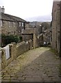
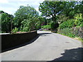
Berry Croft, Honley
A steep cobbled lane from Lane Head down to Thirstin Road.
Image: © Humphrey Bolton
Taken: 28 Feb 2008
0.03 miles
3
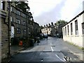
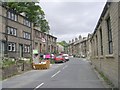
Thirstin Road, Honley
Taken from the roundabout. Thirstin Road follows a valley down into Mag Dale.
Image: © Humphrey Bolton
Taken: 16 Aug 2007
0.04 miles
4
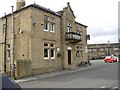
The Liberal Club, Lane Head, Honley
Dated 1905.
Image: © Humphrey Bolton
Taken: 28 Feb 2008
0.04 miles
6
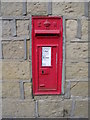
Edward VII Post Box - Thirstin Road
Image: © Betty Longbottom
Taken: 19 Jun 2010
0.04 miles
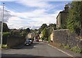
7
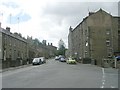
Thirstin Road - viewed from Scotgate Road
Image: © Betty Longbottom
Taken: 19 Jun 2010
0.04 miles
10
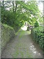
Footpath - Berry Croft, Thirstin Road
Image: © Betty Longbottom
Taken: 19 Jun 2010
0.05 miles