IMAGES TAKEN NEAR TO
Derwent Road, HOLMFIRTH, HD9 6EL
Introduction
This page details the photographs taken nearby to Derwent Road, HD9 6EL by members of the Geograph project.
The Geograph project started in 2005 with the aim of publishing, organising and preserving representative images for every square kilometre of Great Britain, Ireland and the Isle of Man.

There are currently over 7.5m images from over14,400 individuals and you can help contribute to the project by visiting https://www.geograph.org.uk
Image Map
Images are licensed for reuse under creativecommons.org/licenses/by-sa/2.0
Notes
- Clicking on the map will re-center to the selected point.
- The higher the marker number, the further away the image location is from the centre of the postcode.
Image Listing (31 Images Found)
Images are licensed for reuse under creativecommons.org/licenses/by-sa/2.0
Image
Details
Distance
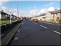
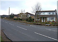
3
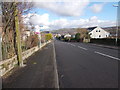
Bradshaw Road - viewed from Derwent Road
Image: © Betty Longbottom
Taken: 7 Feb 2017
0.07 miles
4
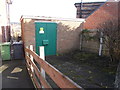
Electricity Substation No 1319 - Moorside Road
Image: © Betty Longbottom
Taken: 7 Feb 2017
0.07 miles
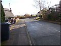
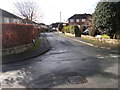
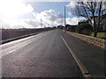
6
Bradshaw Road, Honley
This is the junction with Derwent Road, a residential road on the edge of Honley's built up area. Bradshaw Road at left of shot climbs onto the moor.
Image: © michael ely
Taken: 3 Apr 2008
0.08 miles
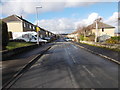
7
Bradshaw Road - viewed from Derwent Road
Image: © Betty Longbottom
Taken: 7 Feb 2017
0.08 miles