IMAGES TAKEN NEAR TO
Slades Lane, HOLMFIRTH, HD9 5RR
Introduction
This page details the photographs taken nearby to Slades Lane, HD9 5RR by members of the Geograph project.
The Geograph project started in 2005 with the aim of publishing, organising and preserving representative images for every square kilometre of Great Britain, Ireland and the Isle of Man.

There are currently over 7.5m images from over14,400 individuals and you can help contribute to the project by visiting https://www.geograph.org.uk
Image Map
Images are licensed for reuse under creativecommons.org/licenses/by-sa/2.0
Notes
- Clicking on the map will re-center to the selected point.
- The higher the marker number, the further away the image location is from the centre of the postcode.
Image Listing (12 Images Found)
Images are licensed for reuse under creativecommons.org/licenses/by-sa/2.0
Image
Details
Distance
1
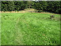
Footpath towards Blackmoorfoot Reservoir
Image: © Chris Wimbush
Taken: 15 Aug 2010
0.09 miles
2
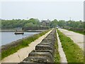
The permissive walk by Blackmoorfoot Reservoir
Along the top of the south eastern dam with the sluice tower and Reservoir House ahead
Image: © Kevin Waterhouse
Taken: 12 May 2024
0.11 miles
3
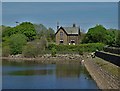
At Blackmoorfoot Reservoir
Looking to a former water board house.
Image: © Neil Theasby
Taken: 14 May 2019
0.15 miles
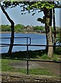
4
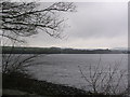
A windswept Blackmoorfoot Reservoir in December
A view NW across Blackmoorfoot Reservoir, Moorside Edge is in the distance with its twin television masts
Image: © Sue Trescott
Taken: 21 Dec 2005
0.17 miles
5
By Blackmoorfoot Reservoir
Looking towards the old waterboard house on the eastern side of the reservoir
Image: © Neil Theasby
Taken: 14 May 2019
0.17 miles
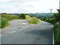
6
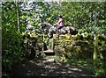
Riding By
A horse rider moves gracefully along a lane south of Blackmoorfoot Reservoir
Image: © Neil Theasby
Taken: 14 May 2019
0.18 miles
7
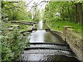
Blackmoorfoot Conduit
The catchwater running over several settlement weirs before entering the reservoir
Image: © Kevin Waterhouse
Taken: 12 May 2024
0.18 miles
8
High Grove Lane, Southowram
This is a narrow windy lane along the top edge of Halifax Cemetery. The upright stone towards the right carries a bench mark.
Image: © Humphrey Bolton
Taken: 22 Mar 2022
0.19 miles
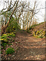
9
Harrison Lane at the junction with a track
The track is a public footpath along Crosland Edge.
Image: © Humphrey Bolton
Taken: 16 Jun 2014
0.20 miles
10
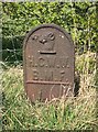
Old Boundary Marker
Water Company Boundary Marker off Harrison Lane, southeast of Blackmoorfoot Reservoir. Meltham parish. H.C.W.W. / B.M.F. (Huddersfield Corporation Water Works / Black Moor Foot) in raised lettering.
Milestone Society National ID: YW_MELWW03em
Image: © K Turner
Taken: 8 Apr 2019
0.22 miles