IMAGES TAKEN NEAR TO
Slaithwaite Road, HOLMFIRTH, HD9 5PT
Introduction
This page details the photographs taken nearby to Slaithwaite Road, HD9 5PT by members of the Geograph project.
The Geograph project started in 2005 with the aim of publishing, organising and preserving representative images for every square kilometre of Great Britain, Ireland and the Isle of Man.

There are currently over 7.5m images from over14,400 individuals and you can help contribute to the project by visiting https://www.geograph.org.uk
Image Map
Images are licensed for reuse under creativecommons.org/licenses/by-sa/2.0
Notes
- Clicking on the map will re-center to the selected point.
- The higher the marker number, the further away the image location is from the centre of the postcode.
Image Listing (14 Images Found)
Images are licensed for reuse under creativecommons.org/licenses/by-sa/2.0
Image
Details
Distance
1
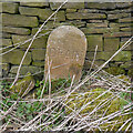
Drain marker stone, Deer Hill End Road, Meltham
I only saw two of these along the road, and the other one is only a few metres away. This was evidently erected here in the days when stone was the cheapest material. I couldn't see a drain, maybe it has been filled in.
Image: © Humphrey Bolton
Taken: 2 Apr 2021
0.07 miles
3
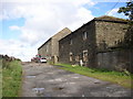
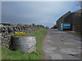
Deer Hill End Road, Meltham
An enclosure road, giving access to two farms and also a public bridleway. It gets rather muddy as it passes the Copley House farm buildings.
Image: © Humphrey Bolton
Taken: 16 Aug 2007
0.08 miles
5
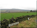
Deer Hill End Road Meltham
This road (bridleway) runs from Deer Hill Reservoir to the north of Meltham. Here we are looking northeast from where it crosses Slaithwaite Road.
Image: © michael ely
Taken: 3 Apr 2008
0.11 miles
6
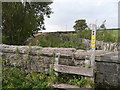
Stile from Deer Hill End Road onto path to Intake Lane, Meltham
This is a permissive path along a catchment drain.
Image: © Humphrey Bolton
Taken: 29 Sep 2015
0.12 miles
7
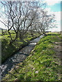
Cascade on the Blackmoorfoot Conduit at Deer Hill End Road, Meltham
A steep section of the conduit is necessary here so that it can pass under the road, which is an enclosure award road, older than the conduit.
Image: © Humphrey Bolton
Taken: 2 Apr 2021
0.12 miles
9
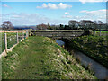
Bridge over Blackmoorfoot Conduit, Meltham
The conduit bisected Spring Head Plantation and the bridge was built to connect the two halves. The plantation existed in 1850 and had nearly all been felled by 1906.
Image: © Humphrey Bolton
Taken: 2 Apr 2021
0.15 miles
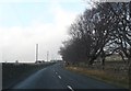
10
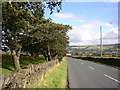
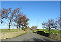
Slaithwaite Road, Meltham
This is a long descent into Meltham town. There is a strip of wood-pasture on the left, being grazed by a horse (not in the picture).
Image: © Humphrey Bolton
Taken: 16 Aug 2007
0.17 miles