IMAGES TAKEN NEAR TO
Blackmoorfoot Road, HOLMFIRTH, HD9 5PS
Introduction
This page details the photographs taken nearby to Blackmoorfoot Road, HD9 5PS by members of the Geograph project.
The Geograph project started in 2005 with the aim of publishing, organising and preserving representative images for every square kilometre of Great Britain, Ireland and the Isle of Man.

There are currently over 7.5m images from over14,400 individuals and you can help contribute to the project by visiting https://www.geograph.org.uk
Image Map
Images are licensed for reuse under creativecommons.org/licenses/by-sa/2.0
Notes
- Clicking on the map will re-center to the selected point.
- The higher the marker number, the further away the image location is from the centre of the postcode.
Image Listing (23 Images Found)
Images are licensed for reuse under creativecommons.org/licenses/by-sa/2.0
Image
Details
Distance
1
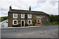
Wills O' Nats Public House on Blackmoorfoot Road
Image: © Ian S
Taken: 5 Sep 2018
0.00 miles
2
Wills O' Nats Public House on Blackmoorfoot Road
Image: © Ian S
Taken: 5 Sep 2018
0.00 miles
3

Wills O' Nats Public House on Blackmoorfoot Road
Image: © Ian S
Taken: 5 Sep 2018
0.01 miles
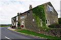
5
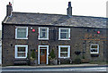
Wills O' Nats, Meltham
Sits beneath Meltham Cop on Blackmoorfoot Road. There was still evidence of the flooding mentioned in the more contextual photograph Image
Image: © michael ely
Taken: 3 Apr 2008
0.04 miles
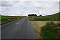
7
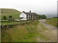
Will o'Nats, Meltham
Formerly called the New Inn. The road sign says 'Flood', which appears to refer to a torrent which evidently ran off Deer Hill End Road on the right, depositing a shoal of stones. Taken from the unsurfaced part of the bridleway from the north.
Image: © Humphrey Bolton
Taken: 12 Jul 2007
0.05 miles
8
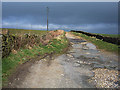
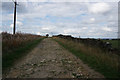
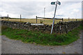
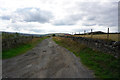
Bridleway over Black Moor
This stretch of bridleway is one kilometre in length and links the Wills O' Nats pub to Holt Head Road to the west of Blackmoorfoot Reservoir.
Image: © michael ely
Taken: 3 Apr 2008
0.06 miles