IMAGES TAKEN NEAR TO
Colders Lane, HOLMFIRTH, HD9 5JG
Introduction
This page details the photographs taken nearby to Colders Lane, HD9 5JG by members of the Geograph project.
The Geograph project started in 2005 with the aim of publishing, organising and preserving representative images for every square kilometre of Great Britain, Ireland and the Isle of Man.

There are currently over 7.5m images from over14,400 individuals and you can help contribute to the project by visiting https://www.geograph.org.uk
Image Map
Images are licensed for reuse under creativecommons.org/licenses/by-sa/2.0
Notes
- Clicking on the map will re-center to the selected point.
- The higher the marker number, the further away the image location is from the centre of the postcode.
Image Listing (212 Images Found)
Images are licensed for reuse under creativecommons.org/licenses/by-sa/2.0
Image
Details
Distance
1
Methodist Burial Ground - Mill Moor Road
Image: © Betty Longbottom
Taken: 29 Oct 2010
0.03 miles
2
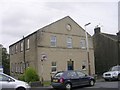
Former Wesleyan Chapel - Mill Moor Road
Built 1819.
Image: © Betty Longbottom
Taken: 29 Oct 2010
0.03 miles
4
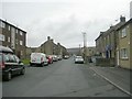
Mill Moor Road - viewed from Westgate
Image: © Betty Longbottom
Taken: 29 Oct 2010
0.03 miles
6
Meltham Methodist Church - Mill Moor Road
Image: © Betty Longbottom
Taken: 29 Oct 2010
0.04 miles
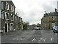
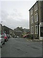
7
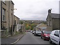
Colders Lane - viewed from Matthew Lane
Image: © Betty Longbottom
Taken: 29 Oct 2010
0.04 miles
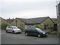
8
Butterflies Children's Day Nursery - Colders Lane
Image: © Betty Longbottom
Taken: 29 Oct 2010
0.05 miles
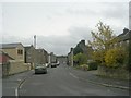
9
Westgate - viewed from Greens End Road
Image: © Betty Longbottom
Taken: 29 Oct 2010
0.05 miles
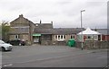
10
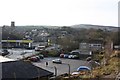
Meltham
A mix of supermarket filling station, car park, Parish Church and houses. Meltham Moor can be seen in the distance.
Image: © Richard Kay
Taken: 14 Jan 2009
0.05 miles