IMAGES TAKEN NEAR TO
Thomas Wroe Way, HOLMFIRTH, HD9 5AN
Introduction
This page details the photographs taken nearby to Thomas Wroe Way, HD9 5AN by members of the Geograph project.
The Geograph project started in 2005 with the aim of publishing, organising and preserving representative images for every square kilometre of Great Britain, Ireland and the Isle of Man.

There are currently over 7.5m images from over14,400 individuals and you can help contribute to the project by visiting https://www.geograph.org.uk
Image Map
Images are licensed for reuse under creativecommons.org/licenses/by-sa/2.0
Notes
- Clicking on the map will re-center to the selected point.
- The higher the marker number, the further away the image location is from the centre of the postcode.
Image Listing (38 Images Found)
Images are licensed for reuse under creativecommons.org/licenses/by-sa/2.0
Image
Details
Distance
1
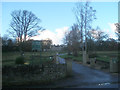
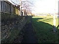
Recreation Ground - off Helme Lane
Image: © Betty Longbottom
Taken: 29 Oct 2010
0.09 miles

5
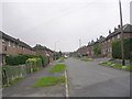
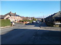
Highfield Avenue - Highfield Crescent
Image: © Betty Longbottom
Taken: 29 Oct 2010
0.13 miles
8
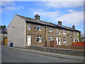
Houses off Broadlands Road, Meltham
One of several short terraces at right angles to the road.
Image: © Richard Vince
Taken: 10 Apr 2019
0.14 miles
9
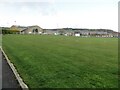
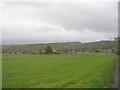
Cricket Ground, Meltham
Looking north-eastward. The building to the left forms part of the Meltham Sports and Community Complex.
Image: © Peter Wood
Taken: 13 Apr 2023
0.14 miles
10
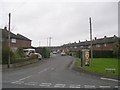
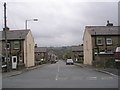
Helme Lane - viewed from Broadlands Road
Image: © Betty Longbottom
Taken: 20 Jan 2017
0.14 miles