IMAGES TAKEN NEAR TO
Albion Gardens, HOLMFIRTH, HD9 5AF
Introduction
This page details the photographs taken nearby to Albion Gardens, HD9 5AF by members of the Geograph project.
The Geograph project started in 2005 with the aim of publishing, organising and preserving representative images for every square kilometre of Great Britain, Ireland and the Isle of Man.

There are currently over 7.5m images from over14,400 individuals and you can help contribute to the project by visiting https://www.geograph.org.uk
Image Map
Images are licensed for reuse under creativecommons.org/licenses/by-sa/2.0
Notes
- Clicking on the map will re-center to the selected point.
- The higher the marker number, the further away the image location is from the centre of the postcode.
Image Listing (56 Images Found)
Images are licensed for reuse under creativecommons.org/licenses/by-sa/2.0
Image
Details
Distance
1
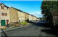
Town houses, Mill Moor Road, Meltham
Many houses have been built on this road during the last several years.
Image: © Humphrey Bolton
Taken: 1 Oct 2021
0.02 miles
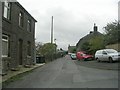
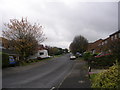
2
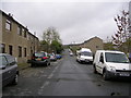
Mill Moor Road - viewed from The Hollow
Image: © Betty Longbottom
Taken: 29 Oct 2010
0.04 miles
3
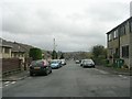
Mill Moor Road - viewed from The Hollow
Image: © Betty Longbottom
Taken: 29 Oct 2010
0.04 miles
7
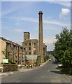
Disused mill, Mill Moor Road, Meltham
The demolition men are at work.
Image: © Humphrey Bolton
Taken: 19 Jul 2007
0.07 miles
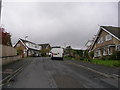
8
Sunny Bank Road - Golcar Brow Road
Image: © Betty Longbottom
Taken: 29 Oct 2010
0.08 miles
9
Hanson Road - viewed from Matthew Grove
Image: © Betty Longbottom
Taken: 29 Oct 2010
0.09 miles
10
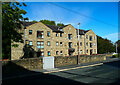
Brookland, Mill Moor Road, Meltham
A block of apartments built on a vacant site.
Image: © Humphrey Bolton
Taken: 1 Oct 2021
0.10 miles