IMAGES TAKEN NEAR TO
Knowle Lane, HOLMFIRTH, HD9 4HL
Introduction
This page details the photographs taken nearby to Knowle Lane, HD9 4HL by members of the Geograph project.
The Geograph project started in 2005 with the aim of publishing, organising and preserving representative images for every square kilometre of Great Britain, Ireland and the Isle of Man.

There are currently over 7.5m images from over14,400 individuals and you can help contribute to the project by visiting https://www.geograph.org.uk
Image Map
Images are licensed for reuse under creativecommons.org/licenses/by-sa/2.0
Notes
- Clicking on the map will re-center to the selected point.
- The higher the marker number, the further away the image location is from the centre of the postcode.
Image Listing (32 Images Found)
Images are licensed for reuse under creativecommons.org/licenses/by-sa/2.0
Image
Details
Distance
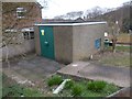
1

Rocks & minerals business, Meltham Mills
Note the mineral specimens to the left of the main door.
Image: © Colin Park
Taken: 18 Jul 2021
0.02 miles
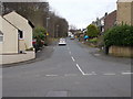
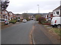
3
Acre Lane - viewed from Thick Hollins Drive
Image: © Betty Longbottom
Taken: 4 Apr 2017
0.11 miles
4
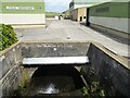
Culvert entrance at Meltham Mills Industrial Estate
The culvert takes Thick Hollins Dike under the large site
Image: © Kevin Waterhouse
Taken: 18 Aug 2024
0.12 miles
5
Electricity Substation No 2198 - Cleveland Avenue
Image: © Betty Longbottom
Taken: 4 Apr 2017
0.13 miles
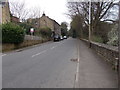
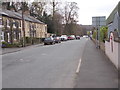
7
Cleveland Avenue - Thick Hollins Drive
Image: © Betty Longbottom
Taken: 4 Apr 2017
0.13 miles
8
Meltham Mills Road - viewed from Mill Bank Road
Image: © Betty Longbottom
Taken: 4 Apr 2017
0.13 miles
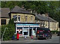
10
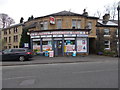
Meltham Convenience Store - Meltham Mills Road
Image: © Betty Longbottom
Taken: 4 Apr 2017
0.14 miles