IMAGES TAKEN NEAR TO
Bent Ley Industrial Estate, HOLMFIRTH, HD9 4EP
Introduction
This page details the photographs taken nearby to Bent Ley Industrial Estate, HD9 4EP by members of the Geograph project.
The Geograph project started in 2005 with the aim of publishing, organising and preserving representative images for every square kilometre of Great Britain, Ireland and the Isle of Man.

There are currently over 7.5m images from over14,400 individuals and you can help contribute to the project by visiting https://www.geograph.org.uk
Image Map
Images are licensed for reuse under creativecommons.org/licenses/by-sa/2.0
Notes
- Clicking on the map will re-center to the selected point.
- The higher the marker number, the further away the image location is from the centre of the postcode.
Image Listing (24 Images Found)
Images are licensed for reuse under creativecommons.org/licenses/by-sa/2.0
Image
Details
Distance
1
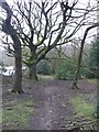
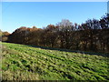
Footpath into Honley Wood from Bent Ley Road, Meltham
Image: © Humphrey Bolton
Taken: 13 Jan 2016
0.09 miles
2
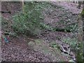
Oldham Spring, Honley Wood, Meltham
The water oozes out of the ground in several places. Why the name 'Oldham'?
Image: © Humphrey Bolton
Taken: 13 Jan 2016
0.15 miles
4
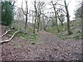
'Cross-paths' in Honley Wood, Meltham
A footpath goes across in front of the holly trees.
Image: © Humphrey Bolton
Taken: 13 Jan 2016
0.15 miles
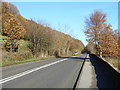
6
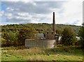
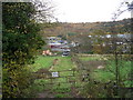
Grazing off Huddersfield Road (B6108)
A branch line from Lockwood (Huddersfield) to Meltham once ran behind the line of trees. The last regular passenger service was on 21st May 1949. It closed completely on 3rd April 1965.
Image: © JThomas
Taken: 15 Nov 2018
0.17 miles
7
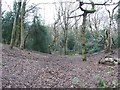
Footpath in a dry valley, Honley Wood, Meltham
Image: © Humphrey Bolton
Taken: 13 Jan 2016
0.17 miles
8

Old Milestone, on the B6108, Huddersfield Road
On downhill into Meltham, 0. 1 mile after Meltham sign. Located on the East side of road, in pavement, back to wall near electricity pole in field. Carved stone post, 19th century. Alternative view see http://www.geograph.org.uk/photo/2139895
Inscription reads: TO / HUDDERSFIELD / 4 MILES / TO / MELTHAM / 1 MILE
Grade II listed by Historic England. see https://historicengland.org.uk/listing/the-list/list-entry/1300373
Milestone Society National ID: YW_HUML04
Image: © Christine Minto
Taken: 31 Dec 2005
0.17 miles
9
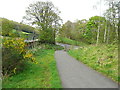
The eastern end of the Meltham cycle path
This is on the former Meltham branch railway line.
Image: © Humphrey Bolton
Taken: 28 Apr 2014
0.18 miles
10
Huddersfield Road (B6108)
Looking north east.
Image: © JThomas
Taken: 15 Nov 2018
0.19 miles