IMAGES TAKEN NEAR TO
Dean Road, HOLMFIRTH, HD9 3XB
Introduction
This page details the photographs taken nearby to Dean Road, HD9 3XB by members of the Geograph project.
The Geograph project started in 2005 with the aim of publishing, organising and preserving representative images for every square kilometre of Great Britain, Ireland and the Isle of Man.

There are currently over 7.5m images from over14,400 individuals and you can help contribute to the project by visiting https://www.geograph.org.uk
Image Map
Images are licensed for reuse under creativecommons.org/licenses/by-sa/2.0
Notes
- Clicking on the map will re-center to the selected point.
- The higher the marker number, the further away the image location is from the centre of the postcode.
Image Listing (6 Images Found)
Images are licensed for reuse under creativecommons.org/licenses/by-sa/2.0
Image
Details
Distance
1
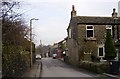
Upperthong
The top end of the village street, at SE127084.
Image: © Humphrey Bolton
Taken: 26 Feb 2003
0.09 miles
4
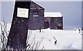
Hillock Farm Upperthong, 1963
Looking North, the driveway is blocked. The Land rover is grounded in the lane at the rear. The tractor also gets stuck. The only way to get anywhere is to walk on top of the dry stone walls! Behind the small red door on the right is a 'two seater' toilet plank!
Image: © Chris Moorman
Taken: Unknown
0.17 miles
5
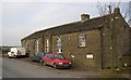
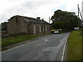
Upperthong School
A small school built in the style of a chapel with its round-headed windows. At the very top of the village.
Image: © Humphrey Bolton
Taken: 26 Feb 2003
0.19 miles
6
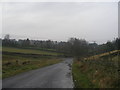
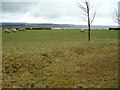
Wolfstones Road, approaching Wickins Lane
Image: © John Slater
Taken: 24 Nov 2012
0.20 miles