IMAGES TAKEN NEAR TO
Moor Lane, HOLMFIRTH, HD9 3UW
Introduction
This page details the photographs taken nearby to Moor Lane, HD9 3UW by members of the Geograph project.
The Geograph project started in 2005 with the aim of publishing, organising and preserving representative images for every square kilometre of Great Britain, Ireland and the Isle of Man.

There are currently over 7.5m images from over14,400 individuals and you can help contribute to the project by visiting https://www.geograph.org.uk
Image Map
Images are licensed for reuse under creativecommons.org/licenses/by-sa/2.0
Notes
- Clicking on the map will re-center to the selected point.
- The higher the marker number, the further away the image location is from the centre of the postcode.
Image Listing (95 Images Found)
Images are licensed for reuse under creativecommons.org/licenses/by-sa/2.0
Image
Details
Distance
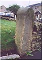
1
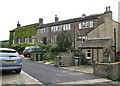
Old milestone
The right face of the stone at the entrance to Lydgett Farm. Inscribed Huddersfild, the s is above the r. The top of the cuffed hand pointing to the left can just be seen.
Image: © Chris Minto
Taken: 12 Jun 2022
0.00 miles
2
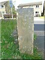
Old milestone
The left face of the old milestone at Lydgett Farm. With imagination, Marfden/5 miles can be discerned.
Image: © Chris Minto
Taken: 12 Jun 2022
0.00 miles
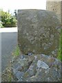
3
Old milestone
At the entrance to Lydgett Farm on Moor Lane, Netherthong is this out of place milestone. It had been used as a gatepost at SE119092 and then on the top of a stone wall. It has mileages to Penistone (penyston) 8 Miles, this face, Marsden and Huddersfield with pointing hands. It is mentioned in WB Crump, Huddersfield Highways Down The Ages P146/147 and may have been at the crossroads Bradshaw Road/Wilshaw Mill Road near where it was used as a gatepost.
Milestone Society National ID: YW_XMELc
Image: © Chris Minto
Taken: 12 Jun 2022
0.00 miles
4
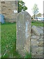
Old Milestone by the B6107, West End, Moor Lane, Netherthong
By the B6107, in parish of Holmfirth (Kirklees District), Moor Lane, Netherthong, South side of lane, right hand side of entrance to Lydgett Farm, post at end of wall.
Surveyed
Milestone Society National ID: YW_XMELc.
Image: © Milestone Society
Taken: Unknown
0.00 miles
5
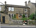
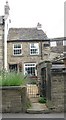
152, Towngate, Netherthong
Nether Cottage
Image: © Alan Longbottom
Taken: 17 Jul 2010
0.01 miles