IMAGES TAKEN NEAR TO
Greengates Road, HOLMFIRTH, HD9 3RG
Introduction
This page details the photographs taken nearby to Greengates Road, HD9 3RG by members of the Geograph project.
The Geograph project started in 2005 with the aim of publishing, organising and preserving representative images for every square kilometre of Great Britain, Ireland and the Isle of Man.

There are currently over 7.5m images from over14,400 individuals and you can help contribute to the project by visiting https://www.geograph.org.uk
Image Map
Images are licensed for reuse under creativecommons.org/licenses/by-sa/2.0
Notes
- Clicking on the map will re-center to the selected point.
- The higher the marker number, the further away the image location is from the centre of the postcode.
Image Listing (5 Images Found)
Images are licensed for reuse under creativecommons.org/licenses/by-sa/2.0
Image
Details
Distance
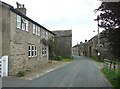
2
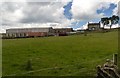
Green Gate
Green Gate Farm and Rawden Hill Farm on Green Gate Road. For a closer shot see Image
Image: © Peter McDermott
Taken: 27 Jun 2015
0.04 miles
4
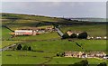
Town End, Austonley
One of many small groups of houses on the hillside above Holmbridge. It must have been regarded as the last row of houses, rather than a farm, on the west side of the district; however there is Upper Town End 300m further west! Note the coal-houses with walk-in access from the road.
Image: © Humphrey Bolton
Taken: 4 Jun 2009
0.20 miles
5
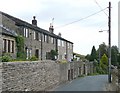
Flush House, Austonley
A small hamlet with farm buildings right up to the road and a terrace of houses with front gardens further on to the left. In the foreground the house is called 'Old Inn' and is shown as a public house on a map of the 1960s and the Odd Fellows Arms on the 1850 map, which shows the hamlet as Flash House.
Image: © Humphrey Bolton
Taken: 4 Jun 2009
0.23 miles