IMAGES TAKEN NEAR TO
Bradshaw Road, HOLMFIRTH, HD9 3RD
Introduction
This page details the photographs taken nearby to Bradshaw Road, HD9 3RD by members of the Geograph project.
The Geograph project started in 2005 with the aim of publishing, organising and preserving representative images for every square kilometre of Great Britain, Ireland and the Isle of Man.

There are currently over 7.5m images from over14,400 individuals and you can help contribute to the project by visiting https://www.geograph.org.uk
Image Map
Images are licensed for reuse under creativecommons.org/licenses/by-sa/2.0
Notes
- Clicking on the map will re-center to the selected point.
- The higher the marker number, the further away the image location is from the centre of the postcode.
Image Listing (17 Images Found)
Images are licensed for reuse under creativecommons.org/licenses/by-sa/2.0
Image
Details
Distance
1
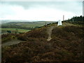
Approaching Wolfstones Height
looking west
Image: © Nigel Homer
Taken: 26 Feb 2006
0.12 miles
2
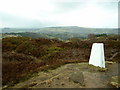
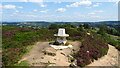
the view from Wolfstones Height looking east
Triangulation Pillar S4400. Castle Hill can be seen to the far left of the photo on the horizon
Image: © Nigel Homer
Taken: 26 Feb 2006
0.12 miles
3
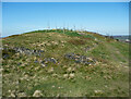
Approaching Wolfstones Height from the west, Netherthong
In the foreground are the remains of a field wall. Trees have been planted in a very exposed position near the summit of the hill.
Image: © Humphrey Bolton
Taken: 22 Apr 2021
0.13 miles
4
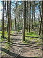
Informal path westwards from Wolfstone Height
Not clear in the image, but I could see a stile into the plantation across the fields, so I had to investigate. The path goes all the way to Bradshaw Road Image], where it is signed as a permissive footpath. Whether it is permissive all the way to Wolfstone Height I don't know.
June 1st, a strong cold wind and rain - I should have brought some gloves.
Image: © Humphrey Bolton
Taken: 1 Jun 2015
0.13 miles
5
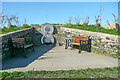
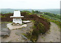
Memorial on Wolfstones Height, Netherthong
A very sad memorial to a nine-year-old boy who loved being up here.
Image: © Humphrey Bolton
Taken: 22 Apr 2021
0.15 miles
6
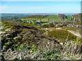
On the summit of Wolfstones Height, Netherthong
The triangulation pillar is not on the summit of the hill, which is a little way to the west. There is an extensive view to the north, with Swinny Knoll (309m) in the centre.
Image: © Humphrey Bolton
Taken: 22 Apr 2021
0.16 miles
7
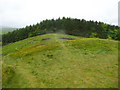
Permissive path from Bradshaw Road to Wolfstones Height, Netherthong
This is an alternative to the short path up from Wolfstones Road.
Image: © Humphrey Bolton
Taken: 22 Apr 2021
0.16 miles
9
Triangulation pillar on Wolfstone Height
At 325m according to the OS Explorer map.
Image: © Humphrey Bolton
Taken: 1 Jun 2015
0.16 miles
10
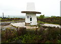
Triangulation pillar on Wolfstone Height, Netherthong
This has the addition of a disk commemorating the Queen's diamond jubilee in 2012, and has been decorated by a stencil of a familiar mask in what I assume to be an anti-establishment gesture.
Image: © Humphrey Bolton
Taken: 1 Jun 2015
0.16 miles