IMAGES TAKEN NEAR TO
Huddersfield Road, HOLMFIRTH, HD9 3JQ
Introduction
This page details the photographs taken nearby to Huddersfield Road, HD9 3JQ by members of the Geograph project.
The Geograph project started in 2005 with the aim of publishing, organising and preserving representative images for every square kilometre of Great Britain, Ireland and the Isle of Man.

There are currently over 7.5m images from over14,400 individuals and you can help contribute to the project by visiting https://www.geograph.org.uk
Image Map
Images are licensed for reuse under creativecommons.org/licenses/by-sa/2.0
Notes
- Clicking on the map will re-center to the selected point.
- The higher the marker number, the further away the image location is from the centre of the postcode.
Image Listing (18 Images Found)
Images are licensed for reuse under creativecommons.org/licenses/by-sa/2.0
Image
Details
Distance
1
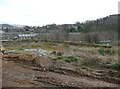
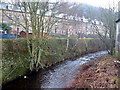
Former millpond, Huddersfield Road, Netherthong
This large pond served Thongsbridge Mills, of which a small part remains (in the distance on the left). The site is about to be developed for housing.
Image: © Humphrey Bolton
Taken: 6 Mar 2008
0.07 miles
2
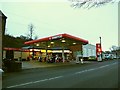
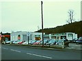
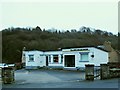
MURCO filling station, Huddersfield Road, Holmfirth
At this time when petrol prices were falling and most garages and supermarkets selling at under £1 a litre, this one was charging 105.9 pence. In a recent forum discussion on this site, "GHo" explained using industry inside knowledge that "smaller companies such as Murco cannot get the same economies of scale or cross-subsidy that the larger ones get. Also, the stuff sold at supermarkets is an inferior product therefore can be sold cheaper."
Image: © Stephen Craven
Taken: 16 Jan 2016
0.10 miles
3
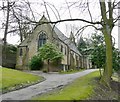
St Andrew's Church, Thongsbridge, Wooldale
A typical late Victorian church in Gothic style with lancet windows and a belfry.
Image: © Humphrey Bolton
Taken: 6 Mar 2008
0.10 miles
4
MOT testing station, Huddersfield Road, Holmfirth
Trading as JPA Motor Co. Ltd.
Image: © Stephen Craven
Taken: 16 Jan 2016
0.11 miles
5
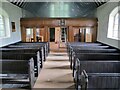
Interior of St Andrew's church, Thongsbridge
For the outside of the church, see Image This is the inside, looking liturgical west (geographically south-west).
The church was built in 1877 as a chapel of ease. A school was added in 1891. There was a burial ground opened in 1938 but it was never used for burials and was sold in 1988.
Note: the building was closed for worship in 2013 and sold to a private owner in 2020 (after this photo was taken) with planning permission for residential conversion, so is no longer publicly accessible. This view shows it as it had been as a place of worship.
Image: © Diocese of Leeds
Taken: 6 Jul 2016
0.13 miles
6
Post Office Huddersfield Road, Thongsbridge, Netherthong (Holmfirth)
Only a mile from the Holmfirth PO, so probably at risk of closure.
Image: © Humphrey Bolton
Taken: 6 Mar 2008
0.13 miles
7
The Mensroom, Huddersfield Road, Holmfirth
A barbers (or as they advertise it, men's grooming service).
Image: © Stephen Craven
Taken: 16 Jan 2016
0.14 miles
8
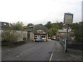
Bridge over the River Holme at Thongsbridge
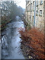
Image: © John Slater
Taken: 8 Oct 2014
0.14 miles