IMAGES TAKEN NEAR TO
High Croft, HOLMFIRTH, HD9 3HE
Introduction
This page details the photographs taken nearby to High Croft, HD9 3HE by members of the Geograph project.
The Geograph project started in 2005 with the aim of publishing, organising and preserving representative images for every square kilometre of Great Britain, Ireland and the Isle of Man.

There are currently over 7.5m images from over14,400 individuals and you can help contribute to the project by visiting https://www.geograph.org.uk
Image Map
Images are licensed for reuse under creativecommons.org/licenses/by-sa/2.0
Notes
- Clicking on the map will re-center to the selected point.
- The higher the marker number, the further away the image location is from the centre of the postcode.
Image Listing (19 Images Found)
Images are licensed for reuse under creativecommons.org/licenses/by-sa/2.0
Image
Details
Distance
1
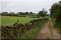
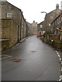
Hill Lane approaching Upperthong
The buildings on the left show inevitable expansion of the village.
Image: © Bill Boaden
Taken: 12 Sep 2014
0.08 miles
2
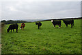
Cows above Holmfirth
Some are happy to stand and stare.
Image: © Bill Boaden
Taken: 12 Sep 2014
0.16 miles
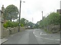
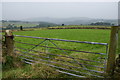
4
View across farmland Hill Lane, Upperthong
Image: © Philip Cornwall
Taken: 24 May 2020
0.18 miles
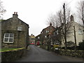
7
Town Gate, Upperthong
The ivy has an autumnal hue.
Image: © Bill Boaden
Taken: 12 Sep 2014
0.20 miles
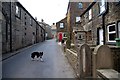
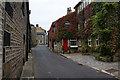
9
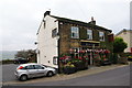
Royal Oak, Upperthong
The village pub which sells Timothy Taylor's Boltmaker. The door is open but it is too early to be open for trading.
Image: © Bill Boaden
Taken: 12 Sep 2014
0.21 miles
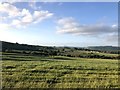
10
Fields above the Holme Valley
Sloping down towards Huddersfield on a grey day.
Image: © Bill Boaden
Taken: 12 Sep 2014
0.21 miles