IMAGES TAKEN NEAR TO
Binns Lane, HOLMFIRTH, HD9 3BL
Introduction
This page details the photographs taken nearby to Binns Lane, HD9 3BL by members of the Geograph project.
The Geograph project started in 2005 with the aim of publishing, organising and preserving representative images for every square kilometre of Great Britain, Ireland and the Isle of Man.

There are currently over 7.5m images from over14,400 individuals and you can help contribute to the project by visiting https://www.geograph.org.uk
Image Map
Images are licensed for reuse under creativecommons.org/licenses/by-sa/2.0
Notes
- Clicking on the map will re-center to the selected point.
- The higher the marker number, the further away the image location is from the centre of the postcode.
Image Listing (359 Images Found)
Images are licensed for reuse under creativecommons.org/licenses/by-sa/2.0
Image
Details
Distance
1
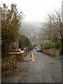
Cooper Lane, Holmfirth
looking towards the own centre on a misty January day
Image: © Nigel Homer
Taken: 8 Jan 2006
0.04 miles
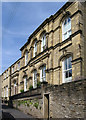
2
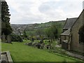
St Johns Church #4
A view over the Holme Valley from the graveyard.
Image: © Mike Kirby
Taken: 23 Apr 2014
0.04 miles
5
Holmfirth Optical Centre - Greenfield Road
Image: © Betty Longbottom
Taken: 11 Aug 2010
0.10 miles
6
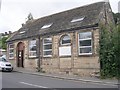
Holmfirth - Lane United Reformed Church
For an alternative view, please see Image This fine building is no longer used as a church.
Image: © Dave Bevis
Taken: 15 Aug 2010
0.10 miles
7
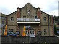
Picturedrome, Holmfirth
It is located at Market Walk
Image: © Kenneth Allen
Taken: 23 Sep 2008
0.11 miles
8
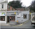
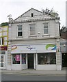
caboodle cards & gifts - Huddersfield Road
Image: © Betty Longbottom
Taken: 11 Aug 2010
0.11 miles
10
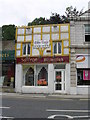
Saffron Bismillah - Huddersfield Road
Image: © Betty Longbottom
Taken: 11 Aug 2010
0.11 miles