IMAGES TAKEN NEAR TO
Upperthong Lane, HOLMFIRTH, HD9 3BE
Introduction
This page details the photographs taken nearby to Upperthong Lane, HD9 3BE by members of the Geograph project.
The Geograph project started in 2005 with the aim of publishing, organising and preserving representative images for every square kilometre of Great Britain, Ireland and the Isle of Man.

There are currently over 7.5m images from over14,400 individuals and you can help contribute to the project by visiting https://www.geograph.org.uk
Image Map
Images are licensed for reuse under creativecommons.org/licenses/by-sa/2.0
Notes
- Clicking on the map will re-center to the selected point.
- The higher the marker number, the further away the image location is from the centre of the postcode.
Image Listing (346 Images Found)
Images are licensed for reuse under creativecommons.org/licenses/by-sa/2.0
Image
Details
Distance
2
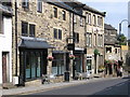
Holmfirth Optical Centre - Greenfield Road
Image: © Betty Longbottom
Taken: 11 Aug 2010
0.01 miles
5
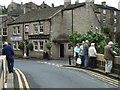
Elephant and Castle, Holmfirth
It is located at Hollowgate
Image: © Kenneth Allen
Taken: 23 Sep 2008
0.02 miles
6
Greenfield Road - viewed from Woodhead Road
Image: © Betty Longbottom
Taken: 11 Aug 2010
0.03 miles
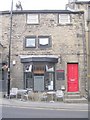
7

Ashley Jackson?s art gallery
Ashley's paintings are available for purchase from his gallery here in Holmfirth.
Image: © Mike Kirby
Taken: 23 Apr 2014
0.04 miles
8
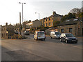
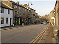
Holmfirth, Greenfield Road (A635)
The junction of Greenfield Road (A635) with Woodhead Road (A6024).
Image: © David Dixon
Taken: 17 Feb 2013
0.04 miles
9
Mezze Bar Restaurant - Woodhead Road
Image: © Betty Longbottom
Taken: 11 Aug 2010
0.04 miles
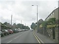
10
Holmfirth, Huddersfield Road
The A6024, entering Holmfirth from the west.
Image: © David Dixon
Taken: 17 Feb 2013
0.04 miles