IMAGES TAKEN NEAR TO
Mission View, HOLMFIRTH, HD9 2TN
Introduction
This page details the photographs taken nearby to Mission View, HD9 2TN by members of the Geograph project.
The Geograph project started in 2005 with the aim of publishing, organising and preserving representative images for every square kilometre of Great Britain, Ireland and the Isle of Man.

There are currently over 7.5m images from over14,400 individuals and you can help contribute to the project by visiting https://www.geograph.org.uk
Image Map
Images are licensed for reuse under creativecommons.org/licenses/by-sa/2.0
Notes
- Clicking on the map will re-center to the selected point.
- The higher the marker number, the further away the image location is from the centre of the postcode.
Image Listing (19 Images Found)
Images are licensed for reuse under creativecommons.org/licenses/by-sa/2.0
Image
Details
Distance
1
Arrunden
View of Arrunden seen from Bare Bones Road.
Image: © Peter McDermott
Taken: 27 Jun 2015
0.03 miles
2
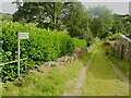
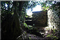
Waltin Road, Arrunden, Cartworth
Despite its name, this is a private driveway and the footpath goes down rather awkwardly to the left and between the laurel hedge and a retaining wall.
Image: © Humphrey Bolton
Taken: 21 Aug 2023
0.03 miles
5
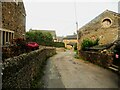
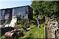
Arrunden Lane, Arrunden, Cartworth
A winding lane through a hamlet.
Image: © Humphrey Bolton
Taken: 21 Aug 2023
0.04 miles
8
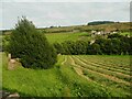
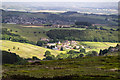
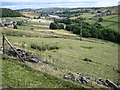
View across the valley of the River Ribble, Cartworth
The buildings are the hamlet of Choppards. The building to the left of them is a former school, later a mission room.
Image: © Humphrey Bolton
Taken: 21 Aug 2023
0.12 miles

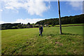
10
Valley of River Ribble near Arrunden
Image: © Chris Wimbush
Taken: 10 Jul 2010
0.16 miles