IMAGES TAKEN NEAR TO
Dunford Road, HOLMFIRTH, HD9 2SZ
Introduction
This page details the photographs taken nearby to Dunford Road, HD9 2SZ by members of the Geograph project.
The Geograph project started in 2005 with the aim of publishing, organising and preserving representative images for every square kilometre of Great Britain, Ireland and the Isle of Man.

There are currently over 7.5m images from over14,400 individuals and you can help contribute to the project by visiting https://www.geograph.org.uk
Image Map
Images are licensed for reuse under creativecommons.org/licenses/by-sa/2.0
Notes
- Clicking on the map will re-center to the selected point.
- The higher the marker number, the further away the image location is from the centre of the postcode.
Image Listing (8 Images Found)
Images are licensed for reuse under creativecommons.org/licenses/by-sa/2.0
Image
Details
Distance
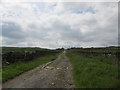
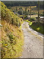
1
Road junction
The junction of Round Close Road to the right and Dunford Road to the left
Image: © Alexander P Kapp
Taken: 20 Aug 2009
0.01 miles
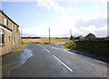
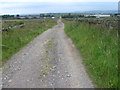
2
Dunford Road towards Hade Edge
Round Close Farm is in the distance.
Image: © Andrew Tatlow
Taken: 23 Apr 2015
0.09 miles
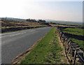
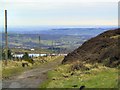
4
View towards Holmfirth
Hade Edge is to the left.The home of Huddersfield Sailing Club, Boshaw Whams Reservoir is in the distance.
Image: © Andrew Tatlow
Taken: 23 Apr 2015
0.15 miles
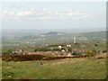
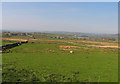
7
Long Ing
Looking north down Holme valley over Long Ing Dike.
Image: © Roger May
Taken: 2 Jan 2006
0.20 miles