IMAGES TAKEN NEAR TO
Green Lane, HOLMFIRTH, HD9 2SL
Introduction
This page details the photographs taken nearby to Green Lane, HD9 2SL by members of the Geograph project.
The Geograph project started in 2005 with the aim of publishing, organising and preserving representative images for every square kilometre of Great Britain, Ireland and the Isle of Man.

There are currently over 7.5m images from over14,400 individuals and you can help contribute to the project by visiting https://www.geograph.org.uk
Image Map
Images are licensed for reuse under creativecommons.org/licenses/by-sa/2.0
Notes
- Clicking on the map will re-center to the selected point.
- The higher the marker number, the further away the image location is from the centre of the postcode.
Image Listing (45 Images Found)
Images are licensed for reuse under creativecommons.org/licenses/by-sa/2.0
Image
Details
Distance
1
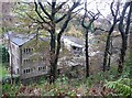
Green Lane Mill, Cartworth
Still in commercial use.
Image: © Humphrey Bolton
Taken: 5 Nov 2009
0.05 miles
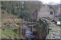
2
The River Ribble at Green Lane Mill, Cartworth
Green Lane Mill (Woollen) is the third mill following the river downstream, and is still in use for industrial purposes. This view is of one of two stone arches over the channel, perhaps built to support a building over the river, and was taken immediately upstream of the mill building. There was a long, thin millpond alongside the river on the eastern side, but this is no longer coloured blue on the large-scale OS map.
Image: © Humphrey Bolton
Taken: 5 Nov 2009
0.05 miles
3
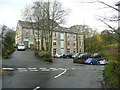
Ribble Bank House, Cartworth
A large three-storey house built on the site of part of the former Dover Mills.
Image: © Humphrey Bolton
Taken: 5 Nov 2009
0.05 miles
4
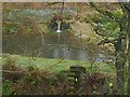
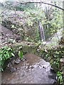
Millpond of Dover Mills, Cartworth
Probably maintained for fishing. Fed by a picturesque waterfall.
Image: © Humphrey Bolton
Taken: 5 Nov 2009
0.06 miles
5
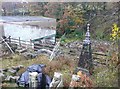
Architectural antiques at Dover Mills, Cartworth
I was particularly intrigued by the steeple. The owner told me that it was from a demolished church, and he had brought it all the way from Wakefield. The remains of the mills are in the background.
Image: © Humphrey Bolton
Taken: 5 Nov 2009
0.06 miles
6
Ruins of Dover Mills, Cartworth
There is little left of the mill buildings, but this wall has some tiling with interesting patterns. Someone might remember working here! It looks as if some new building work has started inside the shell of the old building.
Image: © Humphrey Bolton
Taken: 5 Nov 2009
0.11 miles
7
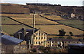
Washpit Mills
Woollen Mill. Powered by 600 hp steam engine until 1980. Sadly missed
Image: © Chris Allen
Taken: 19 Aug 1995
0.13 miles
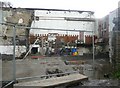
8
Dover Mill, Holmfirth
Construction works next to the banks of the River Ribble
Image: © Richard Kay
Taken: 7 Jan 2015
0.14 miles
9
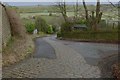
Green Lane, Holmfirth
At the junction with Lamma Well Road, the sets down the middle of the steep lane would have been installed for the benefit of horse-drawn carts, serving the nearby mills.
Image: © Richard Kay
Taken: 7 Jan 2015
0.15 miles
10
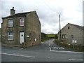
Choppards Bank Road, Holmfirth (Wooldale)
This is its junction with Dunford Road at Cross.
Image: © Humphrey Bolton
Taken: 6 Mar 2008
0.15 miles