IMAGES TAKEN NEAR TO
Dunford Road, HOLMFIRTH, HD9 2SJ
Introduction
This page details the photographs taken nearby to Dunford Road, HD9 2SJ by members of the Geograph project.
The Geograph project started in 2005 with the aim of publishing, organising and preserving representative images for every square kilometre of Great Britain, Ireland and the Isle of Man.

There are currently over 7.5m images from over14,400 individuals and you can help contribute to the project by visiting https://www.geograph.org.uk
Image Map
Images are licensed for reuse under creativecommons.org/licenses/by-sa/2.0
Notes
- Clicking on the map will re-center to the selected point.
- The higher the marker number, the further away the image location is from the centre of the postcode.
Image Listing (42 Images Found)
Images are licensed for reuse under creativecommons.org/licenses/by-sa/2.0
Image
Details
Distance
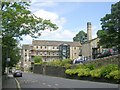
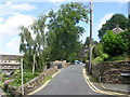
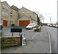
2
The Cragrats theatre, Dunford Road, Holmfirth
Converted from Underbank Mill. The building to the right is a new apartment block on the site of the millpond.
Image: © Humphrey Bolton
Taken: 6 Mar 2008
0.00 miles
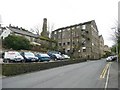
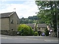
3
Cinder Hill
Old mill chimney by converted mill. Smart apartments below Cinder Hill.
Image: © Roger May
Taken: 2 Jan 2006
0.00 miles
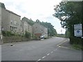
4
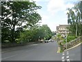
Dunford Road - viewed from Sweep Lane
Image: © Betty Longbottom
Taken: 24 Jul 2010
0.03 miles
7
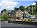
Underbank Working Men's Club - Dunford Road
Image: © Betty Longbottom
Taken: 24 Jul 2010
0.06 miles
8
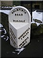
Old Milepost by the B6106, Dunford Road, Holmfirth
Metal plate attached to stone post by the B6106, in parish of HOLME VALLEY (KIRKLEES District), Dunford Road, Holmfirth, near Upper Bankend Road, at end of new wall surrounding new housing development, on East side of road. Brayshaw & Booth iron casting, erected by the County Council in the 19th century.
Inscription reads:-
: SHEFFIELD / 20½ MILES / PENISTONE / 8 MILES : : HOLMFIRTH / ROAD / WOOLDALE : : HUDDERSFIELD / 7 MILES / HOLMFIRTH / ¾ MILE :
Maker:-
: BRAYSHAW & BOOTH / MAKERS / LIVERSEDGE :
Grade II Listed. List Entry Number: 1216089
https://historicengland.org.uk/listing/the-list/list-entry/1216089
Milestone Society National ID: YW_HUSF07.
Image: © C Minto
Taken: 5 Sep 2002
0.06 miles
9
Milestone and Attorney Court, Dunford Road, Holmfirth (Wooldale)
The milestone is so sunk into the tarmac footway that I think it must be 'in-situ' and the driveway of the recent development has been positioned to avoid it.
Image: © Humphrey Bolton
Taken: 6 Mar 2008
0.07 miles
10
Dunford Road - viewed from Sweep Lane
Image: © Betty Longbottom
Taken: 24 Jul 2010
0.07 miles