IMAGES TAKEN NEAR TO
Cote Lane, HOLMFIRTH, HD9 2RP
Introduction
This page details the photographs taken nearby to Cote Lane, HD9 2RP by members of the Geograph project.
The Geograph project started in 2005 with the aim of publishing, organising and preserving representative images for every square kilometre of Great Britain, Ireland and the Isle of Man.

There are currently over 7.5m images from over14,400 individuals and you can help contribute to the project by visiting https://www.geograph.org.uk
Image Map
Images are licensed for reuse under creativecommons.org/licenses/by-sa/2.0
Notes
- Clicking on the map will re-center to the selected point.
- The higher the marker number, the further away the image location is from the centre of the postcode.
Image Listing (27 Images Found)
Images are licensed for reuse under creativecommons.org/licenses/by-sa/2.0
Image
Details
Distance
1
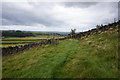
Footpath across the River Ribble at Holme Styes
The lesser-known River Ribble, that is, the Yorkshire one (a minor tributary of the Holme) rather than the Lancashire one. The footpath from Greave Road descends the steep field on the east side of the river, crosses it by a footbridge and turns left to ascend more gently into the woods on the west bank. The body of water on the left is the settling pond of the redundant treatment works (now demolished) - see Image
Image: © Stephen Craven
Taken: 24 Mar 1995
0.15 miles
5
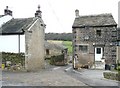
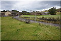
Choppards, Wooldale (former township),Holmfirth
A small hamlet, clustered around a farm. There was formerly a woollen mill down in the valley.
Image: © Humphrey Bolton
Taken: 6 Mar 2008
0.18 miles
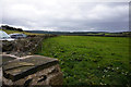
7
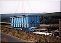
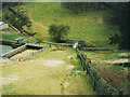
Removing filter units
During the project that saw the abandonment of the old treatment works at Holmestyes Image, temporary facilities were provided adjacent to Cote Lane, consisting of prefabricated DAF (dissolved air flotation - http://en.wikipedia.org/wiki/Dissolved_air_flotation ) and filtration units and chemical dosing, housed in a precast concrete agricultural style building. I don't have a photo of the building, but this is the DAF unit being craned off the site at the end of the project. The concrete base was then broken up and the site grassed over Image The zone was transferred to the new large treatment works at Brownhill Image
Image: © Stephen Craven
Taken: 22 Aug 1995
0.19 miles
9
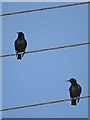
Birds on Wires
Two starlings surveying another December afternoon west of Hade Edge.
Image: © Neil Theasby
Taken: 17 Dec 2013
0.20 miles