IMAGES TAKEN NEAR TO
Cartworth Moor Road, HOLMFIRTH, HD9 2QS
Introduction
This page details the photographs taken nearby to Cartworth Moor Road, HD9 2QS by members of the Geograph project.
The Geograph project started in 2005 with the aim of publishing, organising and preserving representative images for every square kilometre of Great Britain, Ireland and the Isle of Man.

There are currently over 7.5m images from over14,400 individuals and you can help contribute to the project by visiting https://www.geograph.org.uk
Image Map
Images are licensed for reuse under creativecommons.org/licenses/by-sa/2.0
Notes
- Clicking on the map will re-center to the selected point.
- The higher the marker number, the further away the image location is from the centre of the postcode.
Image Listing (8 Images Found)
Images are licensed for reuse under creativecommons.org/licenses/by-sa/2.0
Image
Details
Distance
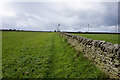
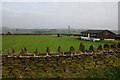
1
Dry stone walls on Cartworth Moor
There are a lot of parallel fields along the moor, compacted a little by zoom.
Image: © Bill Boaden
Taken: 12 Sep 2014
0.10 miles
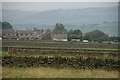
2
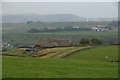
Hill Top Farm
The farm has a hill top site overlooking the valley of the River Ribble. This is looking down from Cartworth Moor Road.
Image: © Bill Boaden
Taken: 12 Sep 2014
0.18 miles
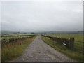
3
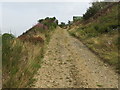
Quarry Track and Bridleway ascending White Gate Edge
Looking north-eastward.
Image: © Peter Wood
Taken: 6 Aug 2018
0.19 miles
4
Cartworth Moor AFC
An amateur football club with a moor top site.
Image: © Bill Boaden
Taken: 12 Sep 2014
0.20 miles