IMAGES TAKEN NEAR TO
Fieldhead Lane, HOLMFIRTH, HD9 2QJ
Introduction
This page details the photographs taken nearby to Fieldhead Lane, HD9 2QJ by members of the Geograph project.
The Geograph project started in 2005 with the aim of publishing, organising and preserving representative images for every square kilometre of Great Britain, Ireland and the Isle of Man.

There are currently over 7.5m images from over14,400 individuals and you can help contribute to the project by visiting https://www.geograph.org.uk
Image Map
Images are licensed for reuse under creativecommons.org/licenses/by-sa/2.0
Notes
- Clicking on the map will re-center to the selected point.
- The higher the marker number, the further away the image location is from the centre of the postcode.
Image Listing (83 Images Found)
Images are licensed for reuse under creativecommons.org/licenses/by-sa/2.0
Image
Details
Distance
2
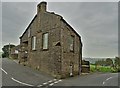
The old school.Holme
I was surprised to find that this is not a listed building. It has a 17C dated lintel over the door (IE 1694), and was rebuilt by subscription in 1838 - see Image for the date stones.
Image: © Humphrey Bolton
Taken: 16 Aug 2017
0.03 miles
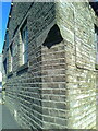
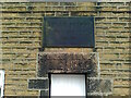
3
Holme Sunday School
The stone plaque on the wall reads "Erected by The Sunday School Teachers 1889". Though still functioning as a Sunday school, the arrival of COVID19 has halted its progress.
Image: © Neil Theasby
Taken: 10 Sep 2020
0.03 miles
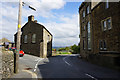
4
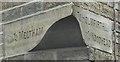
Old Guide Stone, A6024, Woodhead Road, Holme
The guide stone is on the corner of the Sunday school building at the junction of Woodhead Road and Field Head Lane, see https://www.geograph.org.uk/photo/6042953 for a close up view. It can be clearly dated from a plaque on the school recording the rebuilding of the school by public subscription dated 1838, see https://www.geograph.org.uk/photo/6756321
The inscription reads: {left hand} To MELTHAM : To HOLMFIRTH {right hand} / {left hand} To WOODHEAD
Milestone Society National ID: YW_XHOLME
Image: © David Garside
Taken: 27 Mar 2012
0.04 miles
5
Holme School Datestone and Plaque
The school, located at the junction of Fieldhead Lane and Woodhead Road in Holme, was erected originally in 1694 and rebuilt in 1838.
The school, which is now a Sunday school, has an old guide stone on its corner, Milestone Society National ID: YW_XHOLME, which can be clearly dated from the plaque, see https://www.geograph.org.uk/photo/6042953
Image: © David Garside
Taken: 22 Jan 2012
0.04 miles
6
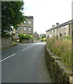
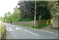
Entering Holme village from the north-east
Image: © Humphrey Bolton
Taken: 16 Aug 2017
0.04 miles
7
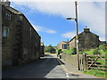
Entering Holme village.
Walking the Holme valley circular walk.
Image: © steven ruffles
Taken: 30 Jun 2015
0.04 miles
9
Old Guide Stone by the A6024, Woodhead Road, Holme Parish
By the A6024, in parish of Holme Valley (Kirklees District), Holme, at junction of Woodhead Road with Fieldhead Lane to Digley Reservoir, on corner of chapel, level with middle of upper floor windows.
Surveyed
Milestone Society National ID: YW_XHOLME
Image: © Milestone Society
Taken: Unknown
0.04 miles
10
The start of the footpath down to the Ramsden Reservoir dam
Image: © Humphrey Bolton
Taken: 16 Aug 2017
0.04 miles