IMAGES TAKEN NEAR TO
Shaw Lane, HOLMFIRTH, HD9 2PY
Introduction
This page details the photographs taken nearby to Shaw Lane, HD9 2PY by members of the Geograph project.
The Geograph project started in 2005 with the aim of publishing, organising and preserving representative images for every square kilometre of Great Britain, Ireland and the Isle of Man.

There are currently over 7.5m images from over14,400 individuals and you can help contribute to the project by visiting https://www.geograph.org.uk
Image Map
Images are licensed for reuse under creativecommons.org/licenses/by-sa/2.0
Notes
- Clicking on the map will re-center to the selected point.
- The higher the marker number, the further away the image location is from the centre of the postcode.
Image Listing (30 Images Found)
Images are licensed for reuse under creativecommons.org/licenses/by-sa/2.0
Image
Details
Distance
1
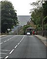
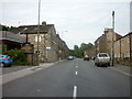
Entering Hinchliffe Mill on Woodhead Road
Image: © Neil Theasby
Taken: 10 Sep 2020
0.07 miles
2
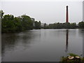
Mill Pond, Holmfirh
Mill pond and Bottoms Mill on a dark summer day.
Image: © Samantha Waddington
Taken: 10 Aug 2011
0.14 miles
4
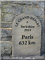
TDF milestone
Tour de France milestone outside the 'Stumble Inn.' This milestone was erected for 'Le Tour de Yorkshire' (July 2014).
Image: © Dave Pickersgill
Taken: 16 Oct 2014
0.16 miles
5
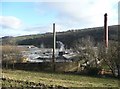
Bottoms Mill, off Woodhead Road, Holmfirth
It is good to see a textile mill still working. Apparently it is a dyeworks, and part of it is used by a builders' merchant.
Image: © Humphrey Bolton
Taken: 8 Jan 2009
0.17 miles
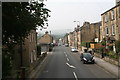
6
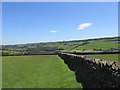
Wallside footpath.
The path follows the same direction through a number of fields.
Image: © steven ruffles
Taken: 30 Jun 2015
0.17 miles
7
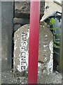
Boundary Stone, Woodhead Road, Holmfirth
This is puzzling; Holmfirth is actually on the left and Austonley on the right. It was probably erected after Holmfirth Urban District was established in 1894, as before that the stone would have been inscribed 'Upperthong' instead of 'Holmfirth'. One clue is that the 1850 six-inch map shows the boundary of a detached part of Austonley here, on the left as shown on the stone. I had assumed that the many enclaves in the Holme Valley of one township within the territory of another had been abolished during the local government reorganisation of 1893, but perhaps this one remained. The maroon pole is a bus stop.
Image: © Humphrey Bolton
Taken: 4 Jun 2009
0.17 miles
9
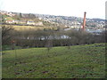
Bottoms Mill, Holmfirth
Looking along footpath to Bottoms Mill and pond in the Holme Valley, near Holmfirth. Built up settlement of Upperthong beyond it.
Image: © Samantha Waddington
Taken: 12 Jan 2013
0.18 miles
10
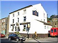
The Shepherd's Rest
Public House on the A6024 between Holmfirth and Holme Bridge.
Image: © Roger May
Taken: 7 Aug 2005
0.18 miles