IMAGES TAKEN NEAR TO
Woodside View, HOLMFIRTH, HD9 2PT
Introduction
This page details the photographs taken nearby to Woodside View, HD9 2PT by members of the Geograph project.
The Geograph project started in 2005 with the aim of publishing, organising and preserving representative images for every square kilometre of Great Britain, Ireland and the Isle of Man.

There are currently over 7.5m images from over14,400 individuals and you can help contribute to the project by visiting https://www.geograph.org.uk
Image Map
Images are licensed for reuse under creativecommons.org/licenses/by-sa/2.0
Notes
- Clicking on the map will re-center to the selected point.
- The higher the marker number, the further away the image location is from the centre of the postcode.
Image Listing (27 Images Found)
Images are licensed for reuse under creativecommons.org/licenses/by-sa/2.0
Image
Details
Distance
1
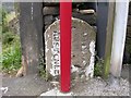
Old Boundary Marker by the A6024, Woodhead Road, Burnlee Bottoms, Holme Valley
Parish Boundary Marker by the A6024, in parish of Holme Valley (Kirklees District), Burnlee Bottoms, on south side of road in front of row of houses partially hidden by post.
Surveyed
Milestone Society National ID: YW_AUSHOL01pb.
Image: © Milestone Society
Taken: Unknown
0.06 miles
2
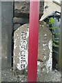
Boundary Stone, Woodhead Road, Holmfirth
This is puzzling; Holmfirth is actually on the left and Austonley on the right. It was probably erected after Holmfirth Urban District was established in 1894, as before that the stone would have been inscribed 'Upperthong' instead of 'Holmfirth'. One clue is that the 1850 six-inch map shows the boundary of a detached part of Austonley here, on the left as shown on the stone. I had assumed that the many enclaves in the Holme Valley of one township within the territory of another had been abolished during the local government reorganisation of 1893, but perhaps this one remained. The maroon pole is a bus stop.
Image: © Humphrey Bolton
Taken: 4 Jun 2009
0.09 miles
3

Old Milestone by the A6024, Woodhead Road, Holme Valley Parish
Carved stone post by the A6024, in parish of HOLME VALLEY (KIRKLEES District), Woodhead Road, Burnlee, by wall opposite lamppost 168, nearly opposite Q8 garage, on South side of road. Holmfirth gritstone, erected by the Huddersfield & Woodhead turnpike trust in the 18th century.
Inscription reads:-
7
Miles to
Huddersfield
Woodhead
(6½)
Grade II listed.
List Entry Number: 1229557 https://historicengland.org.uk/listing/the-list/list-entry/1229557
Milestone Society National ID: YW_HUWH07.
Image: © C Minto
Taken: 1 Nov 2001
0.09 miles
4
Old milestone
The Huddersfield to Woodhead road was a tollroad from 1768 to 1876. Now the A6024. Several milestones survive and some have been repainted. This one is south west of Holmfirth at Burnlee opposite Bryndlee Court. Note the ſ for s in Huddersfield. Grade II listed 1229557.
Milestone Society National ID: YW_HUWH07
Image: © Chris Minto
Taken: 12 Jun 2022
0.10 miles
5
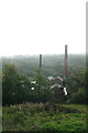
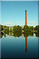
Bottoms Mill from the Woodhead Road on a misty September morning
Image: © Chris
Taken: 11 Sep 2014
0.10 miles
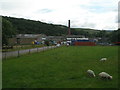
9
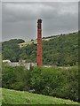
Bottoms Mill Chimney in the Holme Valley
Seen from Woodhead Road
Image: © Neil Theasby
Taken: 10 Sep 2020
0.13 miles
10
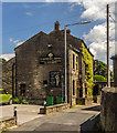
Farmers Arms
The Framers Arms public house in Holmfirth.
Image: © Peter McDermott
Taken: 27 Jun 2015
0.13 miles