IMAGES TAKEN NEAR TO
Greenfield Road, HOLMFIRTH, HD9 2LS
Introduction
This page details the photographs taken nearby to Greenfield Road, HD9 2LS by members of the Geograph project.
The Geograph project started in 2005 with the aim of publishing, organising and preserving representative images for every square kilometre of Great Britain, Ireland and the Isle of Man.

There are currently over 7.5m images from over14,400 individuals and you can help contribute to the project by visiting https://www.geograph.org.uk
Image Map
Images are licensed for reuse under creativecommons.org/licenses/by-sa/2.0
Notes
- Clicking on the map will re-center to the selected point.
- The higher the marker number, the further away the image location is from the centre of the postcode.
Image Listing (21 Images Found)
Images are licensed for reuse under creativecommons.org/licenses/by-sa/2.0
Image
Details
Distance
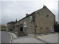
1
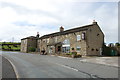
The Ford Inn, Holmfirth
The A635 passes in front of the Inn.
Image: © Julian P Guffogg
Taken: 21 May 2016
0.01 miles
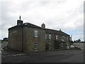
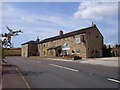
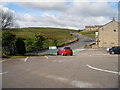
3
The Ford Inn
Taken from the car park of the Ford Inn located at a crossroads on the A635 above Holmfirth.
Image: © Stephen McKay
Taken: 10 Jul 2016
0.03 miles
5
The Ford Inn
Inside, amongst the artwork and pictures is a list of all the landlords of the Inn in chronological order. The current landlord has been in residence since 2002.
Image: © John Tustin
Taken: 13 Apr 2010
0.04 miles
6
The Ford Inn
The Inn sign depicts an early Model A Ford motor car. Real ale, good food, ample helpings.
Image: © Paul Eggleston
Taken: 26 Jul 2008
0.06 miles
8
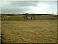
Holmfirth Snape Service Reservoir
off Dean Road, this is not what people would normally associate with a Reservoir.
Image: © Nigel Homer
Taken: 26 Feb 2006
0.08 miles
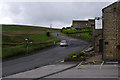
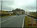
10

The Ford Inn, Greenfield Road, Upperthong
Seen from Green Gate Road. The ford was presumably in the dip, but had already been bridged by 1850, according to the six-inch map of that date, which shows the inn.
Image: © Humphrey Bolton
Taken: 4 Jun 2009
0.10 miles